 |
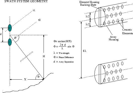
TOBI has recently been modified to make measurements of the seafloor bathymetry across the sonar swaths. The system essentially works by trying to resolve the angle at which the sound travels between TOBI and the seafloor, so that we can use that angle, the travel time of the sound and the depth of the vehicle to compute the bathymetry. The backscattered signal from the seafloor is recorded on two horizontal rows of hydrophones (one pair on each side of TOBI) (Fig.13) and the acoustic angle is found from a slight difference in travel time (or phase) of the signal reaching the two rows of hydrophones. One difficulty with this method is that the difference in phase of signals between the two arrays does not represent a unique angle (caused by the two hydrophone arrays being 8 wavelengths apart) and a major part of our work at sea was to resolve the angle corresponding to this phase difference. This was done using software originally written by a student at the University of Leeds, UK, ([10]) based on the MATLAB ©package [11], and further software re-written by Tim LeBas of the SOC to incorporate it into the PRISM software package ([12]). At sea we upgraded the method (including also the software employed by [10]) to allow manual identification of the phase wraps (lines in the data where the measured phase difference changes by 2pi) and produced initial maps of the bathymetry for the eastern survey area (southeast of Pico, S. Jorge and Terceira). These were mosaicked using the same PRISM-based system used for the sidescan sonar imagery. The initial results show that the port side is poor over most part of the survey, while the startboard side has generally high quality measurements over the inner half of the swath. We expect the final data to be incomplete but will have sections of much higher resolution that traditional multibeam sonar data.