 |
Initial results are presented, in order to address the importance of the preliminary findings and processing sequence of the data acquired.
The OBS were deployed after mapping by multibeam around the proposed sites, in order to identify most suitable areas. The maps in the appendix report the positions for each of them. The proposed sites for piezometers were (a) investigated by CHIRP and multibeam, and by gravity coring. Figure 19 show the CHIRP profiles closer to the deployment sites.
figure
 |
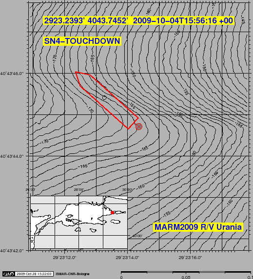
The deployment of the INGV's SN-4 at the entrance of the Gulf of Izmittook place afternoon of 2009-10-04 after intensive mapping by multibeam and chirp and coring by box-corer and gravity corer (Fig.25). The final destination was chosen to be very close to the NAF, on a flat bottom 165m depth on the center of the steep EW striking valley merging a few hundred m to the W with the Darica Canyon.
After the launch at sea (Fig.20) the SN4 touched down on bottom at 15:56:16 (Fig.21 and 22), a few m of cable were layed out and the system was interrogated by acoustic modems. After several attempts with no response from the station, the cable was released at 16:14:47. Ship moved then away some hundred m and after some retries the SN-4 responded at 18:46:00, providing data of orientation (142
![]() ) and of tilt (7-9
) and of tilt (7-9
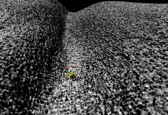
![]() well within specification). The day after the area was again investigated by the MEDUSA, and the SN-4 was seen by the TV camera several times around 07:00:00 laying vertical on the bottom (Fig.23 and 24). A further high resolution mapping by multibeam was then performed attempting to find the target on bottom.
well within specification). The day after the area was again investigated by the MEDUSA, and the SN-4 was seen by the TV camera several times around 07:00:00 laying vertical on the bottom (Fig.23 and 24). A further high resolution mapping by multibeam was then performed attempting to find the target on bottom.
figure
figure
 |
figure
figure
figure
figure
figure
 |
The MEDUSA towed observatory was launched in the areas of the Darica Canyon, of the Structural High and of the Mud volcanoes to the W of Hersek peninsula, with the aim of obtaining visual information on the bottom morphology and instrumental oceanographical and geochemical data. Figures 27, 28 and 29 shows the runlines in the Darica Canyon, and Hersek Peninsula sites, known to be possible degassing areas. The system was generally towed at very low speed or drifting at 0.5-1.5m above bottom, but in particular cases when it was raised up for sampling water at determined levels.
figure
figure figure
Tables 13 and 14 show the positioning data and description of samples.
During the First leg 5 gravity corers were taken close to the Piezometer's location on bottom and will be analyzed at IFREMER for geotechnical and sedimentological determinations useful to correlate data of pore pressures time series from the piezometers.
During the Second Leg two box corers, seven gravity cores and four sediment/water interface cores SW-104 [Magagnoli A. and Mengoli M. (1995)] were collected.
The two box corer sampled the area of SN4 near a zone of black patches evidenced by Medusa surveys, aimed also at sampling possible carbonate crusts. The first box corer sampled mud with shell fragments; the second box corer, sampled again mud and also stones, gravel, shell fragments, more compact mud conglomerates, and with black-blue intrusions which were stocked in plastic bags and deep frozen, together with a small core, for possible microbiological investigations. An attempt to measure methane gave negative result. The washed and seived materials showed black to gray sand to gravel granulometries, shell fragments and normal malacofauna (Fig.30).
figure
Tree gravity cores (MASN_1, MASN_2, MASN_3) were also collected near the SN4 planned deployment site. The first one was immediately sub-sampled for the pore water extraction (Tab. 15). The pore waters were obtained by a squeezer with extraction capacity of four sample in each cycle for slice thickness from minimum of 2 cm to a maximum of 3 cm. Below the 37-39 cm level the long time required for the extraction and the cleaning face between cycles, did not assure the preservation of sulphides in the sample, therefore the sulphide aliquots were not stocked for the successive slices.On 2009-10-06 two SW-104 (MASNSW01, MASNSW02) were sampled in the SN4 area, and the first one was immediately sub-sampled for the pore water extraction by centrifuge (Tab.16), while the bottom water was preserved in glass vials with butyl stoppers.
Table 17 summarize the aliquots type, the adding solvents and the conservation method.
Core MSNSW02, sampled with PVC liner and stocked at 4, during the recovery lost the bottom water, but the structure of the core was preserved because the sediment (plastic, compact and poorly hydrated) functioned like a stopper.
Successively, on 2009-10-07 (a) two gravity cores were sampled in mud volcano area, near Hersek (MSIP01 and MSIP02), (b) one SW-104 (MEISW01)and two gravity cores in Kumburgaz basin and (c) one SW-104 (Flood01) in the area of the recent flooding deposits in front of Büyükçekmece.
The bottom of core MSIP02 contained a well preserved oyster, 10 cm size (Fig.31).
The cores of second leg have been taken in two copies, and were split between ISMAR and ITU.
figure
|
|
A quick processing with SEISPRHO [Gasperini and Stanghellini(2009)] was made on board for navigation and geological target selection, other that structural and stratigraphical analysys. Example of the recorded and processed data are shown in Fig.32, 33, 34 and 35.
The data quality ranged from good to very good, with penetration down to 40 m. Two ultra-high resolution closely-spaced grid of profiles were performed in Tuzla, Izmit, Karamürsel and Gemlik gulfs, to obtain information on NAF offsets and slip rates.
figure
figure
figure
figure