Case Studies
Toward the Digital Twin of the Ocean
Create a digital representation of ocean real-world entities and processes for the Mediterranean Sea
Mediterranean Seascape Case Study
Mediterranean seascape/hydrodynamic provinces/ecoregion identification
Since the seminal work of A. Longhurst who proposed the first "Ecological Geography of the Sea" about 3 decades ago, much effort has been devoted to partitioning the seemingly continuous ocean into “sub-units”. It indeed facilitates the interpretation of transdisciplinary processes and it supports ecosystem monitoring, conservation and management.
While several objective regionalization exercises have been proposed for the Mediterranean Sea, they poorly characterized some crucial areas and/or processes, and they neglected the impacts of fine-scales features. Building upon the latest developments of high-resolution multi-observations satellite products, 4DMED-SEA will generate new eco-regions for two case studies applied to microbes and macro-organisms. Marine life is indeed a vast network of organisms in perpetual interactions and movements, so that their spatial distributions across the seascape results from both physical transport and ecological/biogeochemical processes.
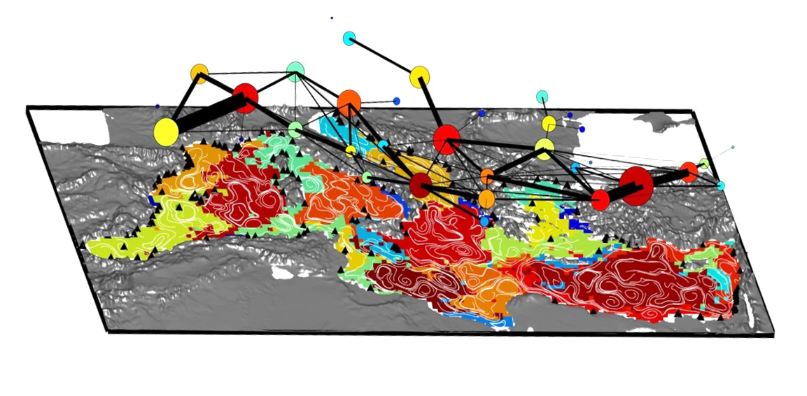
We will first focus on phytoplankton (a key player for primary production and carbon cycling in the ocean) to identify ecoregions (within the Mixed Layer Depth) not only based on chlorophyll-a but also by including information on community composition and organic carbon dynamics. These eco-regions will then be validated using independent dataset such as the regional array of BGC-Argo profiling floats (https://biogeochemical-argo.org). Additionally, we will generate new hydrodynamical provinces at several depths (including the epipelagic, mesopelagic and bathypelagic realms) based on the fine-scale currents of the new 4DMEDSEA product. By providing a synthetic description of all possible transport pathways, it will delimit coherent subregions that inform on population connectivity and structure for macro-organisms that undergo pelagic dispersal as early-life stages, before becoming sedentary adults. Such spatial partitionings will then be interpreted in the context of environmental management, with potential implications for Fisheries, Aquaculture, Marine Protected Areas and contamination risks.
 Copyright @Vincent Rossi
A view of 32 hydrodynamical provinces in the Mediterranean Sea extracted from a basin-scale connectivity matrix simulating 60-day advection of passive larvae during summer 2011 (from Jul.1st to Aug. 29th). White streamlines represent the modeled surface flow averaged over 60 days. Those provinces, and the resulting transport network displayed above using similar color code, organize larval dispersal and control the connectivity of Marine Protected Areas (black triangles) in the entire Mediterranean basin (Adapted from Rossi et al. GRL 2014 doi:10.1002/2014GL059540).


