After the 1999 disastrous Kocaeli earthquake the international community is attempting to produce reliable maps of active faults distribution in the Sea of Marmara. As a follow-up of this effort, within a framework of increasing knowledge of the North Anatolian Fault (NAF) system, a number of scientists is starting to realize that the Sea of Marmara constitute an unique opportunity to study seismogenic behavior of an active fault for several reasons, including the relatively high strain rates observed, and the presence of clear stratigraphic markers at the time scale of several thousand years. Another important point for studying the NAF system below the Sea of Marmara is that here the active fault segments lay close to a highly populated region and will be probably the site of large earthquakes in the next decades.
We believe that an integrated approach involving the acquisition and analysis of geophysical (multibeam, side-scan sonar, chirp), geological (cores) and seismological data, would represent an innovative strategy in the emerging field of “submarine earthquake geology” to assess the seismic hazard in the Marmara region. On the other hand, results from recent marine geological cruises that analysed the almost systematic association of cold seeps (emission of gas and fluids from the seafloor) and active faults in the Marmara Sea highlighted the importance of gathering long term time series to study correlation between fluid vents and seismicity. For this reason, the project includes a geological/geophysical survey in key areas of the Sea of Marmara as well as the deployment of a submarine observatory to monitor the behavior of the fault over a 1 year period.
Diverse earthquake scenarios can be envisioned that would fill the strain gap in the Sea of Marmara between the 1912 and 1999 ruptures, to the western and eastern bounds, respectively. The implications of each scenario for the hazard facing Istanbul (population: 12 million) and elsewhere around Marmara vary widely, and their likelihood needs to be evaluated. These evaluations can only be as reliable as the seismologic, geophysical and geological parameters on which they are based.
Major issues that can be addressed with reliable information on structure and rupture history are:
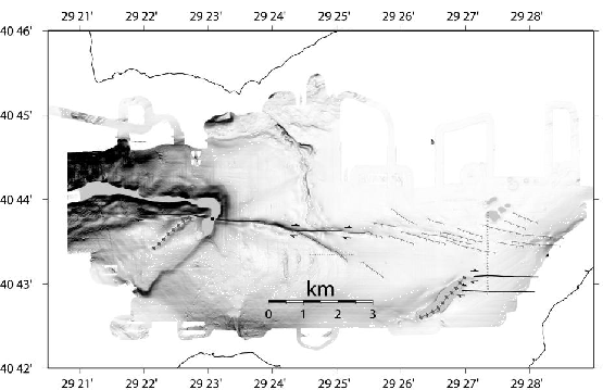
The survey carried out during MARM10_02 combined multibeam, side-scan sonar maps and chirp sub-bottom profiles with carefully positioned core samples to resolve the shallow geometry and kinematics of portions of the fault system in the north eastern Marmara Sea.
Our purpose was to resolve fault geometry and kinematics and to date their most recent ruptures at the same scale as typical paleoseismological studies on land. We were guided by previous and ongoing projects studying larger scale and deeper characteristics of the fault array in the Marmara. Our strategy was to juxtapose morphology and structures along the inferred rupture of the 1999 Izmitearthquake with other faults that may have ruptured in previous historic earthquakes near Istanbul, such as the very large and destructive earthquakes centered in the eastern Marmara sea in 1509 and 1766. Particularly important was to identify features characteristic of submarine ruptures of transcurrent faults which may be subtle in reflection profiles.
figure
 |
The main part of the cruise was devoted to the recovery of submarine observatory (SN-4, OBS and piezometers) after a 1 year deployment along the NAF track in the IzmitGulf (Fig.1 and 2). An extensive seabed sampling and mapping was performed. The fluid escape and interactions were studied by pore water analysis, heat flow measurements and microbiological subsampling.
MARM10_02 was carried out in the frame of MARMESONET project, a demo mission (DM) of the EC funded ESONET Network of Excellence (European Seafloor Observatory Network) that aims at demonstrating the relevance of Seafloor Observatories for monitoring geohazards in the Marmara Region. MARMESONET DM is complementary to KOERI's project MBSO (Marmara Sea Bottom Observatory project), which aims at implementing 5 cabled OBS in the Sea of Marmara, as part of the turkish national network for earthquake and tsunami hazards monitoring. The MBSO project has an operational and research finality, while the MARMARA DM is research-oriented. The former aims at being integrated into the national Turkish seismic network. The latter aims at testing the hypothesis that the physical and geochemical properties of the fluids change within the fault throughout an earthquake cycle and that these changes can be recorded at the seafloor. If true, this hypothesis would open new perspectives to determine whether water and gas circulation in subseafloor environments can generate detectable signals related to the stress-building process before large earthquakes, an issue of direct, social importance.
The collection of data series by bottom observatories was the main objective of the cruise. This implied a site survey prior deployment that included geophysical and geochemical observations carried out directly on board of Urania.
Specific tasks carried out during MARM10_02 cruise were :
Main partners were : ITU(EMCOL) from Turkey, ISMAR and INGV from Italy and IFREMER and PARIS-SUD from France. At the international level, the project also benefits from the participation of scientists from the Scripps Institution of Oceanography (San Diego, California).
The present project is based on many previous research cruises carried out using R/V Odin Finder and R/V Urania and also on cruises of R/V Le Soroit and R/V L'Atalante within the framework of an Italy,France,USA and Turkey collaborative programme. The key areas have been identified through the interpretation of the previously collected geophysical and geological data along the NAF strands and cruise work was designed in order to map active structures and features likely useful to understand fault kinematics. For details about some of these cruises see:
figure
The references in bibliography cover broad aspects of the scientific problems and issues relating to the NAF in the Sea of Marmara, among the many others, tectonics, seismology, geochemical and sedimentary processes SENGOR1979,BARKA92,CAGATAY1998, HUBERT-FERRARI2002, SENGOR2004, SENGOR1985, ARMIJO1999, MCCLUSKY2002, ARMIJO2002,LEPICHON2001,LEPICHON2003,AKSU2000,IMREN2001,GOKASAN2001,KUSKU2009, ALPAR2002,DEMIRBAG2003,BARKA88,BARKA92, STEIN1997, OKAY2000,PARKE2002,FLERIT2003,POLONIA2004,MEADE2002, AMBRASEYS91, PROVOST2003,SHINDLER1997,OKAY2004, POLONIA2002-EOS.
Moreover, in recent years a lot of effort was also devoted to the study of cold seeps, gas and fluid emissions. GELI08 presents the results of geophysical investigations and of submersible dives during cruises MARMARA (R/V Le Suroit, September 2000) and MARNAUT (R/V L'Atalante, May-June 2007), pointing to clearcut evidence of gas and fluid emissions and active tectonics in the Dea of Marmara, particularly in the ÇinarcikBasin. CAGATAY2009 discusses the late Pleistocene-Holocene stratigraphy of the northern shelf of the Sea of Marmara extending back to isotope stage 6. This study reports the discovery of two new sapropel units deposited during isotope stage 5 highstand and discusses water exchange between the Black Sea and Mediterranean through the Sea of Marmara during various isotopic stages, based on seismic stratigraphic and core analyses.