 |
At the start of the cruise a CTD station was done SW of Terceira I.. Some Sippican XBT probes were launched South of Terceira and Pico I. and NW of Terceira I. and N of Pico I.
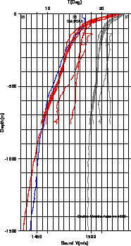
Fig.5 shows the position of the sampling stations. The data are plotted in Fig.11 whereas Table 3 shown time, date and position information.
Once collected, the XBT data were edited to update file headers and to remove bad and suspicious data and immediately put into the database. The depth readings were corrected according to [8]. A few procedures were then prepared for the browsing and plotting of the data, along with the procedures for the creation of the velocity profiles for the sonar reprocessing. These last accounted primarily for the present cruise data for the upper layer down to 700-800 m. After this depth the profiles were integrated with the best available data found in the historical databases.
Two of the XBT launched SE of Terceira presented an anomalous temperature profile. These data will be further analysed and compared with the TOBI CTD data to check this temperature anomaly.