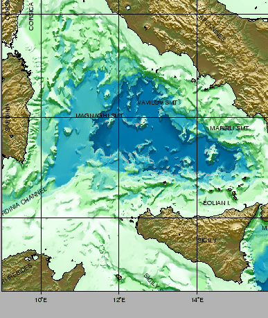
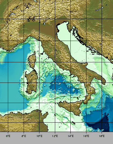
The Tyrrhenian Sea is surrounded to the east and south by the seismically active Apennine-Maghrebid fold and thrust belt, and to the west by the passive margin of the Sardinia-Corsica block. It is the most recent oceanic basin in the Mediterranean. Fig 1 presents the Tyrrhenian Basin within the regional bathymetric and topographic context, whereas Fig. 2 zooms into the area.
The results of ODP Leg 107 [14] showed that initial formation of the basin began in upper Tortonian due to crustal thinning of the plate comprising Corsica, Sardinia and Calabria. The E-ESE directed rifting process continued until upper Pliocene along the western margin. Basinwards, the western Tyrrhenian is characterised by thermal subsidence of the thinned crust and the emplacement, during the lower Pliocene, of oceanic crust in Vavilov basin. Subsequent crustal thinning continues to the east with emplacement of oceanic crust beginning at aprox. 2 My in the Marsili Basin, bordered by the active volcanism associated with the Eolian Island Arc. Characteristic features of the basins are the large volcanic edifices of Marsili , Vavilov and Magnaghi emplaced above the basaltic crust (Fig. 2).
The most widely accepted mechanism to explain the migration in space and time of rifting and oceanic crust emplacement links the eastwards migration of crustal thinning and oceanic accretion to the passive roll-back of the subducting Ionian plate beneath Calabria ([15], [16]). Thinning of the Tyrrhenian lithosphere is explained either by eastwards migrating rifting ([17], [18], [19]) or by east-dipping ([20], [14]) or west-dipping [21] crustal detachment shear zones.
The young age of the Tyrrhenian Sea implies that tectonic and associated volcanic processes exert a strong control on the its sedimentary dynamics and make-up. The western margin represents a typical passive continental margin while the eastern and southern margins are associated with high seismicity, active volcanism and elevated rates of uplift of land areas. In these latter areas, an important contribution to material entering the basin is given by the deposits deriving from both onshore and marine volcanic activity. The deeper parts of the basin are areas of terrigenous and volcanoclastic turbititic accumulation.
Numerous submarine canyons dissect the continental slopes, representing major sediment transport pathways from the margins and slope basins to the deeper parts of the basin. Important additional sediment transfer mechanisms are represented generally by gravitational failures of margins or parts of volcanic edifices triggered by seismic or volcanic activity.
The cruises that are reported here intend to add another dimension to the data collected so far in the Tyrrhenian Sea by investigating in detail the surficial morphology of the basin for the first time. Given the young age of the basin, we have found that much can be deduced about the geodynamic evolution, volcanic activity and sedimentary dynamics of this land-locked sea through time.
figure
 |
figure