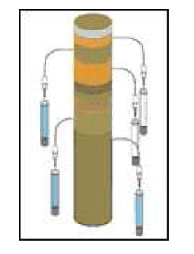
In order to improve knowledge about the fluid-circulation within the Sea of Marmara, the IFREMER group have carried out pore-water extraction and thermal measurements in some selected fluid-active sites. Main focus was the Western High as gas hydrates have been recovered there, and there is ongoing study on their dynamics. A total of 7 cores have been collected on the Western High: 3 on the Northern part of the fault; 3 on the Southern part of the fault and 2 within the fault zone. Upon recovery, the pore waters have been collected for each core and for 4 selected cores, the measurement of the alkalinity has been performed on board. Thermal measurements have also been done on 5 sites (Cores 9A; 8A; 3A; 7I and 10A (Figure 1 & Table 1). Furthermore, we have extracted the pore-water from cores collected on the Izmit (ML04 & ML05) and Gemlik gulfs (ML-01_2) where no seeps activity has been characterized.
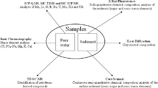
The geochemical analyses of both the pore water and the sediment aim at improving the understanding of fluid migration in chosen location in the Sea of Marmara. Fig.13 shows the methodology. A particular interest was given to the Western High as gas hydrates have been recovered there during the R/V L'Atalante 2007 Marnaut Cruise. The work proposed here in as continuation of the pore water analysis done by M.K.Tryon from samples recovered during the already mentioned Marnaut Cruise TRYON2010.
figure
figure
Thermal conductivities have been measured on-board on the cores in order to determine the thermal conductivity of the sediments. The method of the “hot- needle” has been applied, which consists on the triggering an electric current in a needle. This current releases a certain amount of heat in one impulsion. A temperature sensor inside the needle measures the decrease with time of the temperature straight after the heating; then we can deduce, by the evolution of temperature with time, the thermal conductivity of the sediment.
The WGS84 datum, the UTM35N projection and UTC were chosen for navigation and display, and for data acquisition. The time zone was set to the UTC for the instrumental data acquisition. The positioning maps and bathymetric images were produced with GMT WES95 and Globalmapper. The multibeam data were pre processed on board by the GMT software and ISMAR's routines and scripts, using the SIS production DTMS, after conversion to the ASCII format.
ISMAR'S Bathymetric data were complemented by the IFREMER's DTM of Sea of Marmara IFREMER_BATHY. On-land SRTM topography data was used for mapping, structural analysis, after conversion to NETCDF GMT grid files.
The computing center employed INTEL based PC running the GNU-Linux in addition to portable computer for data acquisition and personal processing. The Linux machines were used as data repositories using the SAMBA software, providing alse network services like WWW, DHCP and NAT.