next up previous contents
Next: SCIENTIFIC AND TECHNICAL PARTIES Up: MARM10_01_REP Previous: Relevant previous or future   Contents


CRUISE SUMMARY

SHIP: R/V Junus S.  Flag: Turkish Call Sign: TC7750
START: 2010-03-26 PORT: Istynie
END: 2010-03-31 PORT: Istynie

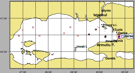
SEA/OCEAN: Sea of Marmara, Mediterranean Sea
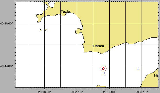
LIMITS: NORTH 40:43.0 SOUTH: 40:44.0 WEST: 29:23.0 EAST: 29:24
OBJECTIVE: Active Faults and historical earthquakes in the Marmara Sea
COORDINATING BODIES: ISMAR-Bologna BOLOGNA (ITALY)
CHIEF OF EXPEDITION: Luca Gasperini (ISMAR-CNR) Giuditta Marinaro (INGV)
CONTACT: Luca.Gasperini@ismar.cnr.it giuditta.marinaro@ingv.it
DISCIPLINES: BOTTOM OBSERVATORIES DEPLOYMENT, WATER SAMPLING,
WORK DONE: SN4 RECOVERY AND DEPLOYMENT, 10 OBS AND 5 PIEZOMETERS RECOVERED, 2 WATER SAMPLING CASTS WITH SUBSAMPLING

LOCALIZATION:

figure

Figure 2: General ship track during Cruise MARM10_01 , including transits from Istynie and Tuzla. Red circle is SN4, blue squares are the Water Sampling Stations.
\begin{figure}\centerline{\epsfig{
file=IMG/MARM10_01_NAV_GEN.eps,width=\linewidth}}
\end{figure}
Figure 3: General ship track during Cruise MARM10_01 , including transits from Istynie and Tuzla. Red circle is SN4, blue squares are the Water Sampling Stations.
\begin{figure}\centerline{\epsfig{
file=IMG/MARM10_01_NAV_CRUISE.eps,width=\linewidth}}
\end{figure}


2010-05-13