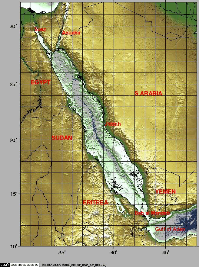
It is generally accepted that the Red Sea and the Gulf Aden rift systems (Fig.1) provide the closest modern anologs to the rifting and rupturing of continental lithoshere that formed the continental passive margins of the Atlantic, Indian and Arctic Oceans. The Red Sea spreading center is believed to have developed within a continental rift following an extended period of rifting, that started in the late Oligocene (30 Ma). The Red Sea continental rift has been mostly extensional and is characterized by the rotation of large crustal blocks such as those exposed in the Gulf of Suez, which initiated as the northern end of the Red Sea during the Late Oligocene-Early Miocene. Most of the extension along the Red Sea was accommodated by sinistral movement along the Gulf of Aqaba-Dead Sea transform that was established in the Middle Miocene, with a second, currently active, phase of movement initiated in the Pliocene ([Bosworth and McClay(2001),Khalil and McClay (2001)].
The development of the spreading centers in the Red Sea varies in magnitude and style along the rift axis. The transition to seafloor spreading is more advanced to the south where the spreading center nucleated near 17N about 5 Ma and propagated both north and south from that location [Cochran (1983),Ghebreab (1998),Bonatti (1985)]. The spreading center axis is continuous south of 21N and it becomes discontinuous northward upto a series of discrete localized centers of intrusion marking where seafloor spreading is nucleating. Thus, the Red Sea shows along-strike all stages involved in the transition from a continental to an oceanic rift.
The project, funded by the EU within the "Euromargins" framework, aimed (a) to clarify tectonic and petrological aspects of the transition from a continental to an oceanic rift and the formation of passive margins, and (b) to address problems of sedimentation in an embryonic ocean and bio-geochemistry in the axial hydrothermal cells. The work at sea would include multibeam, magnetic, gravimetric and seismic reflection surveys, rock and sediment sampling, and water sampling of the axial hydrothermal vents. In addition to processing and interpreting of the geophysical data obtained at sea, a comprehensive analytical program on the geochemistry of igneous rocks and hydrothermal fluids would be undertaken.
The objectives were to study: (1) the northernmost (presumably youngest) troughs with truly "oceanic" crust, and their transition to thinned/stretched continental crust; (2) a fracture zone intersecting the Red Sea (Zabargad Fracture Zone), where the earliest stages in the development of the large oceanic transforms could be observed, and where the north-propagating Red Sea oceanic rift appears to impact at present; (3) the origin and nature of segmentation of the rift axes and offset of the deeps; and (4) the structural architecture of the deeps and the control on localization of the transition zones.
The project also aims to integrate the onshore and offshore data to model the tectonic evolution of the Red Sea rift system. The activities and initial results of the research cruise RS05 in the Northern Red Sea aboard CNR's R/V Urania are presented.
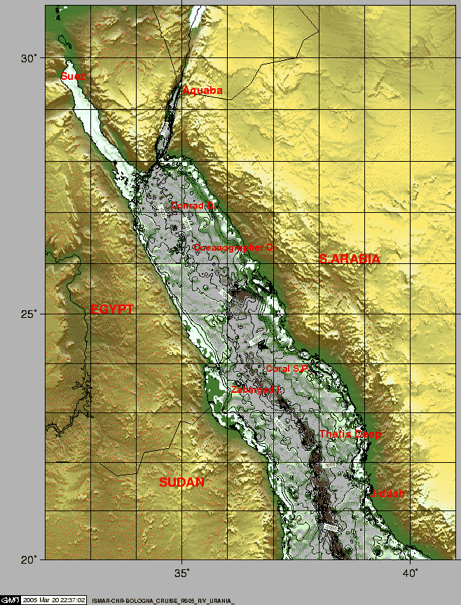
To tackle the above specific topics, we decided to focus our field work on the Northern and transitional regions (Fig.2) trying to obtain high resolution morphobathymetric, magnetometric, SBP and Multi Channel Seismic reflection data, other than bottom rock dredges and brine samples for mineralogical, petrographical and geochemical analysis. In order to achieve our objectives focus was placed on the Northern and transitional areas in the Red Sea (Fig.2). A multi-parameter data acquisition scheme was applied in order to optimize the understanding of the rift system. High resolution morphobathymetric, magnetometric, SBP and Multichannel seismic reflection data were obtained, including rock and sediment samples, brine and water samples to carry-out mineralogical, petrographical and geochemical analyses. Time constraints and permission restrictions restrained the research objectives, and therefore focus was placed on Thetis Deep and its transition to Nereus Deep, a zone previously almost uninvestigated, to test the hypotheses of the evolution from continental to oceanic rifting and the northern propagation of the oceanization process. During the transits we also investigated two of the northernmost Red Sea Deeps, the Conrad Deep and the Oceanographer Deep to sample brines, and the Coral Seapeak, a small seamount of probable igneous origin, looking for deep sea corals.
figure
During the 17 days in the area, including the three days of transit, multibeam bathymetry, magnetics, oceanographic measurements, dredging, coring, surficial sediment sampling and brine water sampling were carried out. The work areas were (a) the Thetis Deep, that was intensively investigated (full coverage multibeam, magnetics, bottom rocks and brine sampling, SBP and MCS seismic), (b) the Coral Sea Peak, that was dredged and mapped, (c) the Nereus, Oceanographer and Conrad Deeps (multibeam, SBP, brine sampling). The Arabian Shelf was sampled by grab and corer. Other activities, e.g. CTD-XBT casts, ADCP and METEO measurements were performed regularly on the way or when dictated by the geophysical acquisition.
R/V Urania sailed from Naples on December 28, 2004 after a delay caused by a storm and arrived at Suez on January 5, 2005. At the end of the cruise, the ship left Port Said in the evening of January 21, 2005 for Venice, where it docked on January 27, 2005 in the evening.
figure
 |