

Next: CHIRP
Up: MATERIALS AND METHODS
Previous: OCEANOGRAPHIC MOORINGS
Contents
CTD casts were taken on surveyed area. Data were collected by a Mod. 911Plus SBE profiling system. CTD data (conductivity, temperature, oxygen, fluorimetry) were taken by a Seabird SBE 11 PLUS interface and SEASAVE V5.33 PC software.
XBT were collected by a Sippican hand-held launcher and a MK21 data logger interface and software(USB).
DGPS NMEA Position data were interfaced directly to the CTD and XBT acquisition systems.
The position of the XBT and CTD stations are reported in Tables 5 and 6, respectively, and can be viewed in Fig. 1.
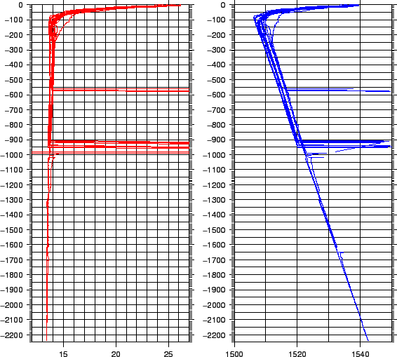
The recorded data were converted to the CNV (for CTD) and EDF (for XBT) formats and further plotted with the ODV software [Schlitzer(2004)]. The Sound Velocity data from the acquired profiles were immediately imported into the PDS-2000 software for multibeam data corrections (see Fig.6.
Table 5:
XBT Stations geographical positions.
| LON |
LAT |
DATE |
TIME UTC |
STATION |
| 11:30.32 |
41:53.05 |
24062007 |
0628 |
2899_T6 |
| 11:35.92 |
41:43.29 |
24062007 |
0734 |
3499_T7 |
| 11:40.30 |
41:36.06 |
24062007 |
0821 |
2199_T7 |
| 11:40.63 |
41:35.50 |
24062007 |
0825 |
2599_T7 |
| 11:47.75 |
41:23.77 |
24062007 |
0941 |
4199_T7 |
| 11:54.37 |
41:12.33 |
24062007 |
1054 |
5499_T7 |
| 12:02.87 |
40:57.53 |
24062007 |
1229 |
2999_T7 |
| 12:08.77 |
40:47.15 |
24062007 |
1336 |
3699_T7 |
| 12:15.27 |
40:35.90 |
24062007 |
1451 |
5199_T7 |
| 12:20.84 |
40:26.03 |
24062007 |
1555 |
5599_T7 |
| 12:26.68 |
40:15.96 |
24062007 |
1700 |
0099_T7 |
| 12:32.69 |
40:04.79 |
24062007 |
1813 |
1399_T7 |
| 12:38.42 |
39:47.88 |
24062007 |
2205 |
0599_T7 |
| 12:52.44 |
39:42.95 |
24062007 |
2316 |
1699_T7 |
| 13:06.20 |
39:38.30 |
25062007 |
0029 |
2999_T7 |
| 13:20.44 |
39:33.37 |
25062007 |
0144 |
4499_T7 |
| 13:29.93 |
39:30.18 |
25062007 |
0909 |
0999_T5 |
| 13:04.30 |
39:00.28 |
25062007 |
1344 |
4499_T5 |
| 13:17.66 |
39:15.63 |
25062007 |
1130 |
3099_T5 |
| 12:53.89 |
38:47.81 |
25062007 |
1518 |
1899_T7 |
| 12:48.51 |
38:41.01 |
25062007 |
1604 |
0499_T6 |
| 12:42.96 |
38:34.10 |
25062007 |
1654 |
5499_T7 |
| 12:37.35 |
38:27.35 |
25062007 |
1745 |
4599_T7 |
| 12:21.81 |
38:08.23 |
25062007 |
2007 |
0799_T6 |
| 11:30.41 |
37:16.33 |
26062007 |
0350 |
5099_T6 |
| 12:48.70 |
38:14.21 |
27062007 |
1254 |
5499_T7 |
| 12:09.45 |
38:08.44 |
27062007 |
0939 |
3999_T6 |
| 12:38.25 |
38:12.33 |
27062007 |
1201 |
0199_T6 |
| 13:03.47 |
38:16.78 |
27062007 |
1410 |
1099_T6 |
| 11:51.00 |
38:06.77 |
27062007 |
0559 |
5999_T7 |
| 11:45.92 |
38:08.63 |
27062007 |
0743 |
4399_T7 |
| 11:54.12 |
38:08.32 |
27062007 |
0825 |
2599_T7 |
|
Table 6:
CTD Stations positions.
| LON |
LAT |
DATE |
TIME UTC |
STATION |
| 1150.7800 |
3807.1900 |
2007-06-27 |
|
214 |
| 1146.0060 |
3808.7058 |
2007-06-27 |
07:41:01 |
215 |
| 1129.22 |
3716.93 |
2007-06-26 |
07:02:00 |
460 |
|
figure
Figure 6:
Cruise MS07. XBT whole data set (temperature, left, Sound velocity, right, unfiltered).
 |


Next: CHIRP
Up: MATERIALS AND METHODS
Previous: OCEANOGRAPHIC MOORINGS
Contents
2007-08-23
