 |
Two workstations were used for (a) ship's guidance, navigation, and multibeam data acquisition by the RESONS's PDS2000 V2.3.4.35 and (2) meteo, conductivity/temperature at the keel, DESO 25 echosounders data acquisition by the Communication Technology NAVPRO V5.6.
The latter workstation collected also the navigation data every 5 minute and at different sampling rates.
The Multibeam data acquisition system interfaced the RESON 8160 Operator's console, a TSS MAHRS gyrocompass and MRU, and the DGPS receiver. Multi serial I/O was accomplished by a MOXA interface.
The NAVPRO system used a Microtecnica Gyrocompass, and the SeaStar GPS receiver with a DGPS Satellite link by FUGRO. The variuos instruments were interfaced by a Digiboard Multi Serial I/O.
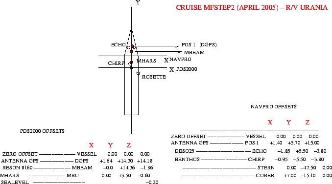
The instrumental offsets are presented in Fig. 15 and in tables 9 and 10.
An RDI ADCP @300Khz and 75 Khz was run almost constantly during work. The positioning and attitude data were provided by a 4 antenna Ashtec GPS and by a MAHRS TSS gyrocompass and attitude sensor.
The SBP sonar data were acquired by Benthos software Chirp2 V3.09, having Latitude and Longitude data sent by the NAVPRO software as instrumental position.
The speed of Sound for DEPTH 1 and 2 was set to 1508m/sec, with a transducer immersion of 3.8m.
The NAVPRO computer interfaced also an AANDERAA meteorological station and a Conductivity/Temperature sensor on the keel at a depth of 3.5m. Data was collected at the same rate as above.
The SBP-CHIRP workstation received the 'VESSEL(0,0)' positions by the NAVPRO serial output. The positions were therefore recorded on the SEGY trace headers.
|
figure