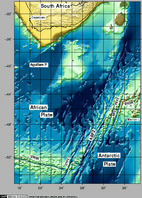
The theory of plate tectonics has shown the Earth to be a dynamic system of shifting lithospheric plates, and the concept of transform faults, introduced by [Wilson (1965)], was one of the key steps in its development. Transform faults offset the axis of mid-ocean ridges and are the locus of strike slip motion at the boundary of the two plates that move sliding past each other. Although large-offset transforms such as the Romanche in the Equatorial Atlantic (longest in the world's oceans) formed the basis of this concept, recent geophysical data have revealed that this and another similar transform in the Southwest Indian Ocean, the Andrew Bain (second longest), do not lie on small circles about the Eulerian POR. An Italian research group of ISMAR-CNR of Bologna [Bonatti et al.(1994),Bonatti et a.(1996),Bonatti et al.(2001),Ligi et al.(2002)] propose that both the Romanche and Andrew Bain transforms represented a new class of oceanic transform boundaries, mega-transforms, "with broad, complex multifault zones of deformation similar to some continental strike-slip systems".
In the austral summer of 1996, Grindlay, Sclater and others carried out a marine geophysical survey (R/V Knorr, cruise KN145-L16) of the ultra-slow spreading Southwest Indian Ridge (Figs.1 and 2) that included a reconnaissance survey of the slowly slipping ABFZ [Grindlay et al.(1996),Grindlay et al.(1998),Sclater et al.(2005)].
The Italian research team proposed, jointly with GIN-RAS, to lead a marine geological and geophysical expedition to the same transform in austral summer 2005-2006, within the framework of the PNRA, and invited the Sclater and Grindlay teams to participate in the cruise, to share respective data and to collaborate in the post-cruise data analysis. The geological and geophysical data from the new expedition, when combined with data collected by Grindlay and Sclater, will provide a complete view of the morphology, tectonic fabric and physical structure of the Andrew Bain transform domain.
The PNRA approved fundings and a cruise was scheduled early 2005 with the GIN-RAS R/V Strakhov , with work at sea including multibeam, magnetic, gravimetric, seismic reflection surveys and rock sampling. In addition to processing and interpretation of the geophysical data obtained at sea, a comprehensive analytical program on the geochemistry of mantle and igneous rocks was also planned. The scientific objectives of the analysis of the geological and geophysical pointed:
The activities and initial results of the research cruise S23-AB06 in the Andrew Bain aboard GIN's R/V Strakhov are presented hereinafter. During the survey, multibeam bathymetry, magnetics, gravity, SBP, reflection seismic, dredging, were carried out. Other activities, e.g. CTD and SVP casts, and METEO measurements were performed regularly on the way or when dictated by the geophysical acquisition. R/V Strakhov sailed from Capetown 2006-02-10, 12:00 local time. At the end of the cruise, the ship docked in Capetown March 10, 2006 at 12:00 local time.
figure