 |
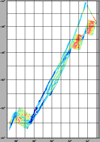
The MBES was the 12 kHz, 234 2° beams, 150°aperture RESON 8150, capable of acquiring data at full ocean depth. The sonar data were collected and recorded in realtime on HD by direct interfacing of the sonar processor 81P to the PDS-2000 software. Two data sets were generated and stored on separate computer for backup on HD and CD/DVD. The PDS-2000 software was able to build a 130 m DTM during the acquisition of the entire surveyed area. The data of cruise KN145-L16 [Grindlay et al.(1998)] were downloaded from the Ocean Ridge Multibeam Database at LDEO as netcdf GMT grids. The data (see Fig.7) were converted from geographical latitude and longitude coordinates to the Direct Mercator 48S projection, and a PDS-2000 DTM was generated and input to the acquisition workstation. The coverage was used for filling gaps and for extending the KN145-L16 survey westward and eastward . Once in the working area and after the extensive test for calibration, it was found that the KN145-L16 and the newly acquired datasets had no significant misalignments or offsets in the overlapping areas. The two multibeam datasets will therefore be used for an up-to-date regional bathymetric compilation. Backscatter data were recorded in the XTF format and will be processed post-cruise.
A suite of real-time data were collected during the survey, including the Simrad-like format (multibeam) and XTF (reflectivity data). The Simrad-like files were used for extensive post-processing with the MB-System [Caress and Chayes (2004)], PDS-2000 and Kongsberg-Simrad's Neptune.
figure