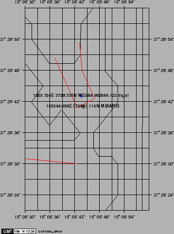
Upon departure in Catania (2-feb-1999), we established an absolute reference point at ship's docking (Molo sporgente Centrale), thanks to the cooperation of IIV (Dr. Carbone) (Fig. 29. A SCINTREX portable gravimeter Mod. CG-M was used from absolute point at the Palazzo delle Scienze to the ship point. The coordinates of ship POS1 during the measurements are reported on Fig. 29: the WGS84 coordinates are the centroid of 20 min. acquisition from NAVPRO, whereas the M.Mario coordinates were converted by DATUM (Ligi and Bortoluzzi, 1988). The GMT coastline (probably ED50) and the Molo Centrale Coordinates (from map N. 272 of Istituto Idrografico Della Marina, M.Mario) are reported as well.
Upon departure in Civitavecchia (4-mar-1999) the gravimeter was calibrated against the absolute point in the harbour (courtesy of Dr. Cesi, Servizio Geologico Nazionale), which was found to be at a distance less that 600 m.
After a 4 hour of thermal and electronic stabilization, the value of the on board gravimeter was read for a period of time of 6 hours. The values were then averaged and the result was set as the instrumental zero.
During the cruise the dynamic characteristics of the system was measured two times. The procedure consisted of changing the pressure on the springs of the pendulum and reporting the response at the logging PC. In addition to this, the temperature inside the sensor and the horizontal stability of the gyroscopic platform were checked every hour. These latter were found to be well within the instrumental characteristics. At the end of the cruise in Catania, the above procedure was repeated and the resulting reading was set as the total drift of the instrument. The ship was docked at a distance of about 300 m from the absolute point that was established at the departure.