


Next: DATA DIRECTORY ORGANIZATION
Up: SWATH BATHYMETRY DATA PROCESSING
Previous: DEPTH PROCESSING
Contents
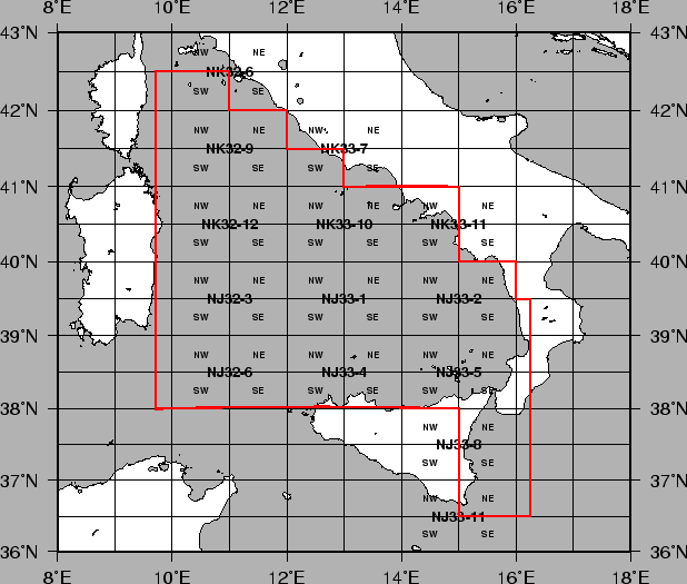
The choice of the cartographic outputs underwent the following guidelines (see Fig. 26):
- division of the whole surveyed area in 1 x 2 Degrees Latitude and Longitude
sheets at the scale 1:250000 according to the Join Operation Group (JOG) cuts, to be produced
with the UTM and Mercator projections. Accordingly, the names of the maps
follow the JOG numbering (e.g. NJ32_6).
- division of each JOG sheet in 4 working maps at the scale of 1:100000 (Direct Mercator on 40N),
extending 2 km WSEN of the geographical limits. The names of the map follow the
JOG numbering and quadrant (e.g. NJ32_6SW, NJ32_6SE, NJ32_6NE, NJ32_6NW).
In some cases the limits were extended, with an E added to the map name.
figure
Figure 26:
Cartographic coverage
 |
The gridding and DTM production (IRAP) underwent the following guidelines:
- preparation of all previuos data (including grids and single beam) for the input to IRAP
and datum transformation to WGS84 if necessary.
- reading and storing of the xyz NEPTUNE files in the SIMRAD STB format (Direct Mercator on 40N),
and straight conversion to UTM 32 or 33 of the STB file if necessary (procedure stb2stb).
- production of the DTM 100x100 m for each of the above 1:100000 working maps
(Direct Mercator on 40N)
(search radius 1000m, number of quadrant 4, number of point per quadrant 8);
- production of the DTM 250x250 m 1:250000 (Direct Mercator on 40N) by regridding the 4 1:100000
DTMs (search radius 1250 m, number of quadrant 4, number of point per quadrant 8).
- straightforward production of GMT netcdf grids from the IRAP grids (procedure gri2grd)
- production of larger DTM's of the whole area
- production of higher resolution maps at scales ranging from 1:25000 to 1:100000 on most
interesting areas.
- compilation and backups of the digital data
The processing flow was automated by some procedures that created the command files to be executed
in batch by IRAP, on the basis of each particular JOG map and of the data files that were found to
be present on the area.
The STB datafile names were created with the NEPTUNE block numbering, plus:
nn_CRid.ellprj.stb
nn = block
CRid = cruise and Area ID
ell = W for WGS84, E per ED50
prj = m40 for Mercator 40, u33 UTM zone 33
The naming of the processed grids is Name_of_the_project.GRI
Next: DATA DIRECTORY ORGANIZATION
Up: SWATH BATHYMETRY DATA PROCESSING
Previous: DEPTH PROCESSING
Contents
2001-07-13