We had several difficulties in launching the XBT's. First, in the Sardinia Channel and SE of Sardinia, the weather conditions were very bad and, moreover, the launching station was situated at mid ship, toward the bow, thus increasing the probablity that the wire went onboard when launching downwind. We at last positioned the launching station at stern. Nonetheless, the ship towed seismic arrays and streamers, and a magnetometer. Several probes were thus lost.
Due to the fact that surveying with multibeam, seismic, magnetics and gravity poses some sharp limitations to the steering of the ship, the only clear strategies when crossing areas with higly varying water mass properties can be:
Clearly, strategy (1) requires a much larger economic investment and a tighter sampling, in terms of success of every launch and ship's guidance and control. In contrast, strategy (2) may have the disadvantage of a possible undersampling of some specific areas. For both (1) and (2), however, it is highly recommended that at some points the full hydrologic properties of the water masses are investigated, by CTD or XCTD profiles. In addition, it should be stated that the analysis of the seasonal oceanographic conditions of the investigated areas has to be performed for the proper planning and execution of the survey. Whether available, additional tools like Satellite Surface temperature data may be helpful during the survey.
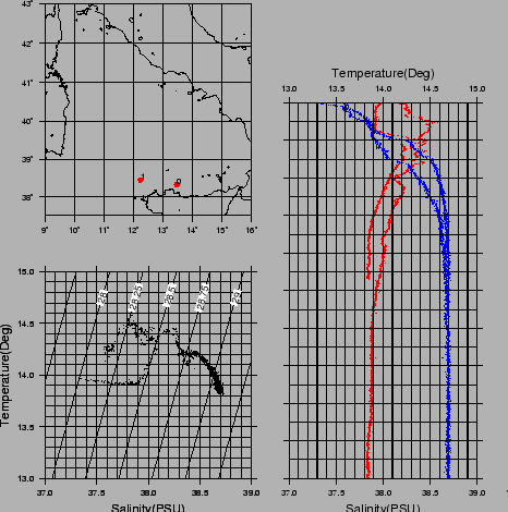
figure
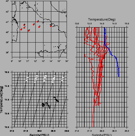
figure
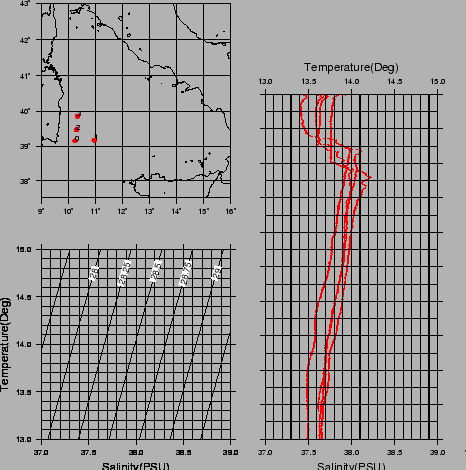
figure