


Cruise Report TYRRMOUNTS09
CNR ISMAR – Istituto di
Scienze Marine
TYRRMOUNTS09 Cruise Report
8 May – 3 June 2009
Edited by K. Schroeder and M. Borghini
Consiglio Nazionale
Università degli Studi di
delle Ricerche - IAMC
Genova
Istituto Nazionale di
Istituto Nazionale di Fisica
Geofisica e
Nucleare
Vulcanologia
Istituto Nazionale di
Oceanografia e
Geofisica Sperimentale
1
Cruise Report TYRRMOUNTS09
Contents
Cruise Details
3
Scientific Objectives
4
TYRRMOUNTS09 – LEG 1
6
Scientific Staff
7
Scientific Background
8
Cruise Plan
10
Cruise Maps
11
Cruise Stations
12
Sampling Strategy
13
Onboard Operations
14
Preliminary results
20
TYRRMOUNTS09 – LEG 2
6
Scientific Staff
7
Scientific Background
8
Cruise Plan
10
Cruise Maps
11
Cruise Stations
12
Sampling Strategy
13
Onboard Operations
14
Preliminary results
20
2
Cruise Report TYRRMOUNTS09
Cruise Details
NAME
TYRRMOUNTS09
DATE
8 May – 3 June 2009
WESTERN IONIAN SEA
SICILY CHANNEL
STUDY AREA
SARDINIA CHANNEL
TYRRHENIAN SEA
PROJECT RESPONSIBLE
G.P. GASPARINI, CNR-ISMAR
HEAD OF MISSION
MIRENO BORGHINI, CNR-ISMAR
CHIEF SCIENTIST
G.P. GASPARINI, CNR-ISMAR
CNR – ISMAR
CNR – IAMC
INFN
PARTICIPANT INSTITUTES
INGV
UNIVERSITY OF GENUA
OGS
RESEARCH VESSEL
URANIA
DEPARTURE PORT
RAVENNA
ARRIVAL PORT
CIVITAVECCHIA
3
Cruise Report TYRRMOUNTS09
Scientific Objectives
This report presents the preliminary results obtained during the TYRRMOUNTS09 cruise, carried out
from 8th May – 3rd June 2009, on board of the Italian R/V URANIA in the Western Ionian Sea, in the
Central Mediterranean (leg 1) and in the Tyrrhenian Sea (leg 3).
The cruise was addressed to acquire information on physical, biological and geochemical processes of
the water column and the sediment in the whole study area. More in detail:
Leg 1 (Ionian Sea & Central Mediterranean):
CTD-LADCP
stations,
recovering
and
deployment of moorings, box-corers of deep
sediments for macrobenthos studies.
Leg 2 (Tyrrhenian Sea):
CTD-LADCP stations,gliders,box-corers,
Buckets
The cruise was planned in the framework of three different projects (corresponding to the legs of the
cruise):
1.
KM3Net: During the last years, the European Commission has approved the funding for the
project stage of an enormous astronomic telescope, based on the detection of the neutrino. The
Italian collaboration Nemo has the aim to present a competitive solution of the whole detector,
called Nemo Km3. There are also other European proposals, like Nestor in Greece and Antares
in France, which lay on the same physical principle and has developed for the past ten years
the independent project VLVNT (very large volume neutrino telescope). Only recently a
European collaboration has started, which is called Km3net, in which the research experiences
of the three solution are integrated and which is funded by the EC.
2.
SESAME – Southern European Seas: Assessing and Modelling Ecosystem changes: SESAME
aims to assess and predict changes in the Southern European Seas (Mediterranean and Black
Sea) ecosystems and in their ability to provide key goods and services with high societal
importance, such as tourism, fisheries, ecosystem biodiversity and mitigation of climate
change through carbon sequestration in water and sediments. In particular we are involved in
the workpackages WP2 and WP3, which deal with data collection for model definition and
validation along 'WOCE-type' lines and in sub-regional seas. In this particular case the area
investigated was the Sicily Strait.
3.
MIUR-PRIN 2007 program “Thyrrhenian Seamounts ecosystems
In this frameworks, the cruise was planned in order to achieve the following objectives:
1.
The physical cruise in the western Ionian is intended to provide updated information on the
hydrology in the KM3 area, to recover a mooring, and to deploy another one.
2.
The cruise in the Sicily Strait is intended to provide CTD, nutrients, data along transects
between Sicily, Sardinia and Tunisia.
4
Cruise Report TYRRMOUNTS09
3.
The cruise in the Tyrrhenian Sea aims to identify and describe the physical forcings acting in
seamounts systems. The knowledge of hydrographic processes controlling the circulation, the
mixing, and the exchanges of water masses around seamounts is the basis for the
understanding of biogeochemical processes. For each seamount it is intended to determine
their influence radius on biogeochemical processes and on primary production.
5
Cruise Report TYRRMOUNTS09
TYRRMOUNTS09 leg 1
8 – 19 May 2009
6
Cruise Report TYRRMOUNTS09
Scientific Staff
CNR-ISMAR
Sede di La Spezia
Borghini Mireno
Technician
19036 Pozzuolo di Lerici
Bacciola Domenico
Technician
Italy
Schroeder Katrin
Researcher
tel: +39.0187.978300
Baldrighi Elisa
PhD Student
fax: +39.0187.970585
Sede di Trieste
Sparnocchia Stefania
Researcher
viale Romolo Gessi 2
34123 Trieste
Italy
tel. +39 040 305 312
fax: +39.040 308941
CNR-IAMC
Sede di Oristano
Ribotti Alberto
Researcher
19036 Pozzuolo di Lerici
Italy
tel: +39.0187.978300
fax: +39.0187.970585
INFN
Laboratori Nazionali di Frascati
Cordelli Marco
Researcher
Via E. Fermi 40,
Habel Roberto
Researcher
00044 Frascati
Trasatti Marco
Researcher
Italy
Simeone Francesco
PhD Student
Masullo Rocco
Researcher
INGV
Via Pezzino Basso, 2
Sartini Ludovica
PhD Student
95125 La Spezia
Italia
tel: +39.0187. 794415
7
Scientific Background
The Ionian Sea
The Ionian Sea is one of the eastern basins. It is bordered by Italy, Greece, Libya and Tunisia and has a
volume of 10.8 x 10⁴ km3. The basin is connected to the Cretan Sea through the Straits of Kithira
(depth 160 m and width 33 km) and of Antikithira (depth 700 m and width 32 km), to the Levantine
Basin through the Cretan Passage, to the Adriatic Sea through the Otranto Strait (depth 780 m and
width 75 km) and to the Western Mediterranean through the Sicily Strait.
The thermohaline circulation of the eastern basin is composed of two cells. The first one is an internal
cell, deep and vertical, which involves the Ionian and the Levantine Basins. This deep thermohaline
cell, the “conveyor belt” of the Eastern Mediterranean, is maintained by a deep water source in the
Adriatic Sea, with the Eastern Mediterranean Deep Water (EMDW) reaching the Levantine Basin with
a renewal time of 126 years (Roether and Schlitzer 1991; Schlitzer et al., 1991; Roether et al., 1994).
During the 90’s also another deep water source located in the Aegean Sea was observed (Roether et al.
1996). The external cell comprises water exchanges between the eastern and the western basin and
with the North Atlantic. The Atlantic Water (AW), which enters the Mediterranean through the Strait
of Gibraltar, moves eastward, spreading through the entire Mediterranean Se, after passing the Sicily
Strait, occupying a layer of about 200 m depth. At the same time, the Levantine Intermediate Water
(LIW), which forms mainly in the north-eastern Levantine Basin, moves westward, in a layer between
200 and 600 m depth, exiting the Mediterranean towards the North Atlantic, where it constitutes the
well-known MOW (Mediterranean Outflow Water). In the Ionian Sea there are water and property
exchanges with the Levantine Basin, in the East, and with the Aegean Basin, in the North. It is
therefore considered a transition basin for all eastern water masses, where they are subject to
important mixing and transformation processes along their pathway.
The main Ionian water masses are the Atlantic Water (AW), which moves eastward from the Sicily
Strait, in the surface layer and is normally identified by a subsurface salinity minimum, between 30 m
and 200 m depth. Below the AW, there is the Levantine Intermediate Water (LIW), which enters the
Ionian Sea through the Cretan Passage, spreading westward from its formation site, the north-eastern
Levantine Basin. The LIW is identified by its salinity maximum, between 200 and 600 m depth. The
abyssal layer, below 1600 m, is occupied by the Eastern Mediterranean Deep Water (EMDW), colder
and less saline, that forms mainly in the Adriatic Sea. In the layer comprised between 700 m and 1600
m, we find a transition water mass, with intermediate properties between the LIW and the EMDW. To
these water masses, we have to add the Ionian Surface Water, ISW, which is clearly distinguishable
from the AW in summer in the surface layer, being warmer and saltier than the AW.
The deep EMDW has well-defined core properties, because it is less influenced by the transformation
processes. On the other hand, the distinguishing properties of the AW and the LIW has modified
during their pathway, and depend on the distance from their formation sites. In the table, the AW and
LIW properties in the eastern sub-basins are indicated (from literature, Manzella et al., 1988; De Maio
et al., 1990; Moretti et al., 1993; Ozsoy et al., 1993; Theocharis et al., 1993; Malanotte-Rizzoli et al.,
1997).
8
Cruise Report TYRRMOUNTS09
The Central Mediterranean Sea
The Central Mediterranean is characterized by a very complicated bottom topography, which directly
affects the water exchange between the two Mediterranean basins (western and eastern Mediterranean
Sea). The most salient features are the unequal depths of the boundary sections (Astraldi et al., 2002).
In the Sardinia Channel (section D13-D21 in Figure 1), the sill depth is at about 1900 m, allowing the
free exchange of the deep waters with the WMED, but in the Sicily Strait (section 410-432), the deeper
sill is at about 430 m, thus imposing strong constraints on the exchanges with the EMED. In between,
a wide area of very shallow waters off Tunisia provides a further obstacle to a direct connection
between the two basins. All water masses outflowing at depth, both from the WMED (Krivosheya and
Ovchinnikov, 1973; Hopkins, 1988) and from the EMED (Astraldi et al., 1996), are conveyed into the
Tyrrhenian Sea, an intermediate basin whose southern part strongly interacts with the central
Mediterranean. Section 212-291 is substantially formed by two main channels with a wide plateau in
between. The deeper one, in the central part, directly connects the Tyrrhenian Sea with the Sardinia
Channel and the WMED, and the other, adjacent to the Sicilian slope, connects, with an increasing
depth, the Sicily Strait with the Tyrrhenian Sea.
The Sicily Strait, which represents the connection between western and eastern sub-basins, has a
central role in the Mediterranean circulation. The Strait is a topographically complex region consisting
of two sill systems separated by an internal deep basin (fig. 1): the eastern sill with a maximum depth
of about 540 m connects the Strait with the Ionian Basin, the central basin presents deep trenches
deeper than 1700 m, while the western sill is composed of two narrow passages, which have a
maximum depth of 530 m. The entire region has a minimum width of 140 km and a total length of 600
km. The width of the Strait, significantly large at the surface, sensibly reduces in depth. Dynamically,
the Strait is a two layer system: the surface layer (about 200 m thick) is occupied by the Atlantic
Water (AW), moving eastward, while the deep layer, occupied by the Levantine Intermediate Water
(LIW), flows in the opposite direction. The dynamics of the Strait is rather complex: the surface layer
(AW) is dominated by mesoscale processes, while for the underlying layers the topography plays a key
role. The Bernoulli effect associated to the high LIW velocity permits the Ionian deep water, laying at a
greater depth, to cross the eastern and the western sills and to reach the western basin (Astraldi et al.,
2001). In literature this water mass is called the transitional Eastern Mediterranean Deep Water
(tEMDW). The high depth permits the central region to act as an intermediate reservoir between the
eastern and the western sills, especially for the subsurface waters. Important mixing is also observed in
correspondence of the sills, where high velocities induce significant entrainment effects with the
surrounding waters (Iudicone et al., 2003; Stansfield et al., 2003).
9
Cruise Report TYRRMOUNTS09
Cruise Plan
The following table 1 summarizes the parameters that have been measured and the groups involved in
the sampling operations, while table 2 lists the sampling equipment and the methods of analysis.
Parameters/Instruments
Working Group
CTD/O2/Fluorescence/Trasmissometer/rosette
CNR-ISMAR
Salinity
CNR-ISMAR
Dissolved Oxygen
CNR-ISMAR
ADCP
CNR-ISMAR
LADCP
CNR-ISMAR
NO3, PO4, SiO4
ENEA
Meteo station on board
CNR-ISMAR
Attenuation length of light
INFN
Macrobenthos and parameters characterizing
CNR-ISMAR
the deep sediments
Table 1 Measured Parameters
Small-Volume Sampling
General Oceanics 24-place rosette with 12-liter bottles
CTD System
CTD SBE 911 plus
Salinometer
GUILDLINE AUTOSAL
Dissolved Oxygen
Winkler titration
ADCP
RDI WH 300 kHz, RDI OS 75 kHz
LADCP
RDI WH 300 kHz
NO3, P04, SiO4
Samples only, no on board analyses
Meteo station on board
AANDERAA
Sediment sampling
Oceanic Box-corer
Astronomic telescop
Nerone
Table 2 Sampling equipment and analysis methods
The track is shown in Figure 2. For this leg we planned to spend 12 days at sea. The geographic
boundaries of the survey are 35.0 °N – 39.5 °N latitude and 8 °E - 17 °E longitude.
The station list is shown in table 3.
10
Cruise Report TYRRMOUNTS09
Cruise Maps
Figure 2 Station map
11
Cruise Report TYRRMOUNTS09
Cruise Stations
Station
Lon (°E)
Lat (°N)
Depth (m)
ACTIVITY
Nk3
36.317
16.149
3385
CTD – LADCP – Oxygen
KC1
36.316
16.092
3437
CTD – LADCP – Oxygen – Salinity
KM4
36.267
16.101
3463
CTD – LADCP – Oxygen
Nk4
36.332
16..000
3437
CTD – LADCP
Nk5
36.375
15.833
3508
CTD – LADCP
Km3
36.501
15.834
3419
CTD – LADCP – Oxygen
Nk6
36.402
15.657
3383
CTD – LADCP
Nk8
36.434
15.517
1181
CTD – LADCP – Oxygen
Nk9
36.433
15.467
341
CTD – LADCP
Nk7
36.417
15.583
2228
CTD – LADCP
605
36.501
13.502
806
CTD – LADCP – Oxygen
D13
38.7861
8.8000
130
CTD – LADCP – Nutrients
D14
38.5943
8.8000
900
CTD – LADCP – Nutrients
D15
38.3936
8.8000
1600
CTD – LADCP – Nutrients – Oxygen
D16
38.1917
8.8000
2500
CTD – LADCP – Nutrients – Oxygen
D16A
38.2910
8.8000
2208
CTD – LADCP
D16B
38.0460
8.8110
1993
CTD – LADCP
D17
38.0101
8.8000
1800
CTD – LADCP – Nutrients – Oxygen –
Salinity
D17B
38.0101
8.8000
1800
CTD – LADCP
218
38.2320
11.5310
229
CTD – LADCP – Nutrients
261
38.9140
10.0150
1500
CTD – LADCP – Nutrients
291
39.0080
9.7830
1004
CTD – LADCP
241
38.8560
10.1830
2560
CTD – LADCP – Nutrients – Oxygen
231
38.8050
10.2570
2345
CTD – LADCP – Nutrients
12
Cruise Report TYRRMOUNTS09
225
38.5330
10.8680
730
CTD – LADCP – Nutrients
227
38.6320
10.6820
1575
CTD – LADCP – Nutrients
229
38.7220
10.4940
2460
CTD – LADCP – Nutrients – Oxygen
212
38.0500
12.0900
220
CTD – LADCP – Nutrients
214
38.1200
11.8460
1160
CTD – LADCP
216
38.1480
11.7170
951
CTD – LADCP – Nutrients
217
38.1810
11.6660
762
CTD – LADCP – Nutrients – Oxygen
219
38.3060
11.4280
890
CTD – LADCP – Nutrients – Oxygen –
Salinity
221
38.4340
11.2467
686
CTD – LADCP – Nutrients
223
38.4670
11.0770
840
CTD – LADCP – Nutrients – Oxygen -
Salinity
Table 3 List of stations
13
Cruise Report TYRRMOUNTS09
Sampling Strategy
The stations have been selected mainly based on previous knowledge and available literature. The
hydrological characteristics of the study area have been determined by CTD cast. In order to achieve
information about the spatial variability of nutrients a high-resolution sampling has been applied, at
the standard depths (table 4). For a better sampling of the biological and chemical parameters, extra
sampling depths were defined in the water column by analyzing the CTD profile during the acquisition.
The same standard depths have been sampled for the probe calibration against Winkler titration (for
dissolved oxygen) and salinity determination.
Level
Standard depths (m)
1
0
2
25
3
50
4
75
5
100
6
200
7
300
8
400
9
500
10
750
11
1000
12
1250
13
1500
14
1750
15
2000
16
2500
17
3000
18
3250
19
3500
Table 4 Standard depths
14

Cruise Report TYRRMOUNTS09
Onboard Operations
CTD Casts
At all the hydrological stations, pressure (P), salinity (S),
potential
temperature
(θ)
and
dissolved
oxygen
concentration (DO) were measured with a CTD-rosette
system consisting of a CTD SBE 911 plus, and a General
Oceanics rosette with 24 12-l Niskin Bottles. Temperature
measurements
were
performed
with
a
SBE-3/F
thermometer, with a resolution of 10-3 °C, and conductivity
measurements were performed with a SBE-4 sensor, with a
resolution of 3 x 10⁻⁴ S/m. In addition, salinities of water
samples were analyzed on board using a Guildline Autosal
salinometer. Dissolved oxygen was measured with a SBE-13
sensor (resolution 4.3 μM), and data were checked against
Winkler titration. The vertical profiles of all parameters were
obtained by sampling the signals at 24 Hz, with the
CTD/rosette going down at a speed of 1 m/s. The data were
processed on board, and the coarse errors were corrected.
Laboratory: ISMAR-CNR
LADCP
Two Lowered Acoustic Doppler Current Profilers (LADCP) were used to measure velocity profiles. We
used two RDI Workhorse 300 kHz ADCP. For data post-processing we used the LDEO LADCP
(versione 8.1) software.
Laboratory: CNR-ISMAR
Inorganic Nutrients
Seawater samples for nutrient measurements were collected at different depths, when the system
CTD/rosette was going up, according to the vertical profiles of salinity, potential temperature and
dissolved oxygen, recorded in real time. No filtration was employed, nutrient samples were stored at –
20°C and nitrate, orthosilicate and ortophosphate concentrations will be determined later in the
laboratory, using a hybrid Brän–Luebbe AutoAnalyzer following classical methods (Grasshoff et al.,
1983) with slight modifications.
Laboratory: CNR-ISMAR in collaboration with ENEA
15
Cruise Report TYRRMOUNTS09
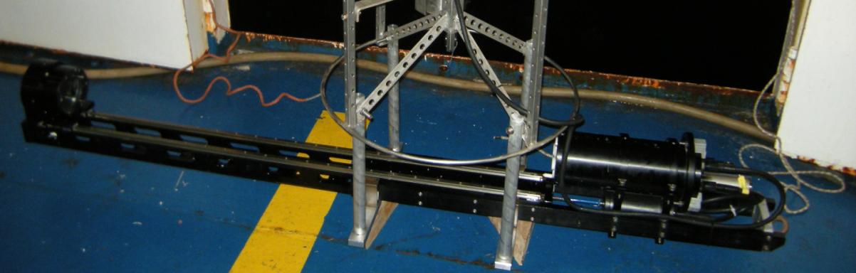
NERONE
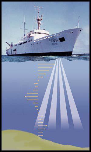
NERONE is an instrument designed and built at INFN to measure the attenuation length of light in
water. This project has been developed in the framework of the environmental studies for the NEMO
group and the km3net European project for a 1 km3 Cerenkov neutrino detector in the Mediterranean
sea. NERONE measures the attenuation length of light in water by changing the light path with the
movement of a reflector along a rail. The measurement is thus independent of calibrations and
comparisons with pure water. During the cruise several deployments have been performed to varying
depths, with a final deployment to 2500m which has finally proven the functionality of the instrument.
NERONE before deployment GEMS mounted in mooring cage, with its power supply
Vessel-mounted ADCPs
The hydrographic data set has been integrated with direct current
measurements. During the whole campaign two VM-ADCPs (RDI
Ocean Surveyor, 75 KHz, and RDI Workhorse, 300 KHz) which
operated during the whole campaign, along the whole ship track. The
depth range of the two current profilers is about 700 m (OS75) and
150 m (WH300). Data acquisition is carried out using the RDI
VMDAS software vers. 1.44. The ADCP data will be submitted to a
post-processing with the CODAS3 Software System, which allows to
extract data, assign coordinates, edit and correct velocity data. Data
will be corrected for errors in the value of sound velocity in water,
and misalignment of the instrument with respect to the axis of the
ship.
Laboratory: CNR-ISMAR
16

Cruise Report TYRRMOUNTS09
Recovering and deployment of moorings
One mooring, deployed in November 2008 in the NEMO position (KC1), was recovered and not
redeployed. A mooring specifically designed for the assessment of biofouling has been deployed almost
in the same position.
Laboratory: CNR-ISMAR and INFN
Macrobenthos and sediment analysis
The primary goal was to investigate the deep macrobenthic
communities (in terms of abundance, biomass, distribution
and diversity) in the Ionian sea, along the Maltese continental
slope. Sediment samples were taken for biological and
biochemical analyses, in order to characterize the deep
macrofauna associations in relation to the main
environmental characteristics of the area. Three different
depths along the slope were selected: 1200 m, 1700 m and
2000 m, performing three deployments in each station.
Sediment samples were collected with a box-corer (size: 32
cm diameter, 52 cm height) and subsamples were collected
using Plexiglass liners of 5,5 cm and 3,6 cm internal diameter.
Sediment subsamples were collected to analyze the
biochemical composition of organic matter (chlorophyll a,
phaeopigments,
carbohydrates,
lipids
and
proteins),
heterotrophic prokaryote production, protozoa abundance,
meiofaunal abundance, biomass and diversity, granulometry.
All the sediment in the box corer have been collected for
macrofauna.
Laboratory: CNR-ISMAR
17
Cruise Report TYRRMOUNTS09
Preliminary Results
Weather conditions
The diagrams in figure 3 show the sea and weather conditions during the cruise.
Figure 3 Evolution of the weather conditions between 11th and 21th March 2008 (air
temperature, sea temperature, relative humidity, air pressure, wind rose, irradiance)
18
Cruise Report TYRRMOUNTS09
Hydrology
In the following some preliminary hydrological data and current measurements (LADCP data) of the
western Ionian Sea are presented.
Hydrographic sections
Figure 4 Distribution of potential temperature, salinity and oxygen along the transect nk9-nk3,
transect 291-212 and transect d13-d17
19
Cruise Report TYRRMOUNTS09
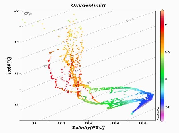
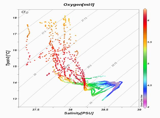
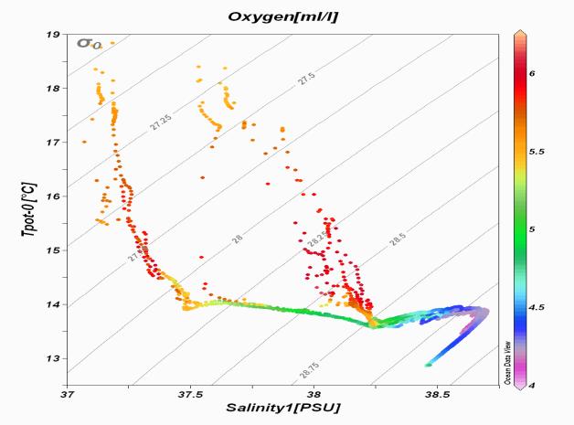
Potential Temperature vs Salinity Diagrams
Figure 6 Theta-S diagram of the whole water column along the transect nk9-nk3 (left) and
transect 291-212 (right), transect d13-d17 (below)
. Colours indicate oxygen concentrations
20
Cruise Report TYRRMOUNTS09
Currents from LADCP
Figure 7 Distribution of the measured velocity (normal component) in m/s along transect
nk3-nk9 (above), 212-291 (centre), d13-d17 (below). Positive values are northeastward.
21
Cruise Report TYRRMOUNTS09
22

Cruise Report TYRRMOUNTS09
Eulerian measurements
A moorings was recovered after its deployment in November 2008, in the NEMO position (KC1). It
was not redeployed. The data were downloaded from the internal memories. In the following graphs
we show some preliminary data elaborations.
Figure 12 Scheme of the KC1 mooring, recovered at 36°18.97’ N and 16°05.48’ E
23

Cruise Report TYRRMOUNTS09
Figure 13 Scheme of the Biofouling mooring, deployed at 36°18.97’ N and 16°05.48’ E
24

Cruise Report TYRRMOUNTS09
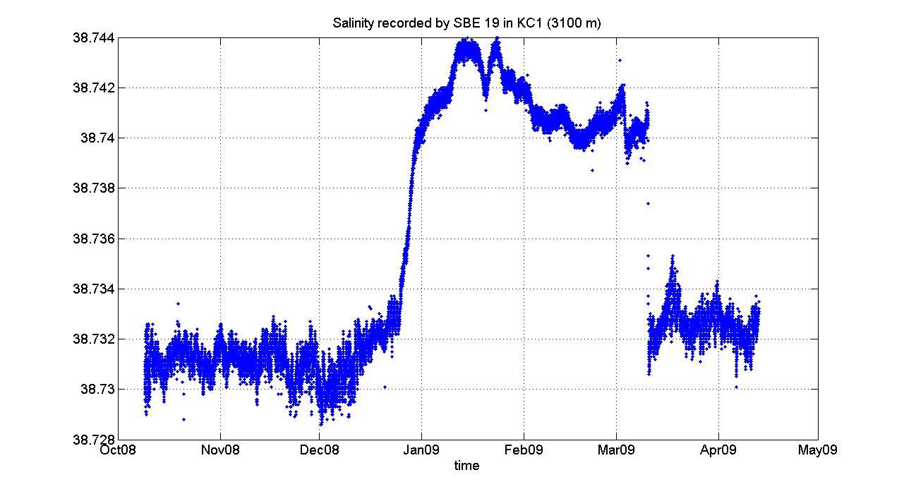
Figure 17 Temporal evolution of potential temperature and salinity measured by an SBE19 at
3150 m depth in the KC1 mooring
25

Cruise Report TYRRMOUNTS09
Figure 20 Currentmeter AQUADOPP at 3400 m depth in the KC3 mooring: velocity and angle
histogram
26
Cruise Report TYRRMOUNTS09
Characterization of bathyal macrofauna
The first 20-30 centimeters of the sediment in the box-corer
were sieved using a 0,5 mm and 0,3 mm sieving in order to
collect all macrobenthic organisms. Before sieving a visual
observations of the surface cores was regularly performed and
the organisms were immediately picked. All the macrofauna
was preserved in 10% buffered formalin with Bengal Rose and
then transferred to 80% alcohol. After a preliminary and
quick sorting, all macrofauna found seemed to be mainly
polychaetes, scaphopods and foraminifera; few molluscs and
pteropodes shells. A huge quantity of white filter feeding
polychaetes characterised the superficial sediment in station 2
and in station 3. A detailed sorting and identification of the organisms will be subsequently made in
the laboratory, to estimate the abundance and diversity of the macrobenthic communities.
Each box-corer was sub-sampled using two Plexiglas liners of 5.5 cm for organic matter, prokaryote
production and meiofauna and one Plexiglas liners of 3.6 cm for granulometry. Chemical and
biological analyses were carried out on three replicates (from independent deployments) at each
sampling station. For the heterotrophic prokaryote production the 0-1, 3-5 and 10-15 cm of three liners
were immediately used to perform these analyses on board. For the organic matter and prokaryote
diversity, sediment corers were sliced into different layers: 0-1, 1-3, 3-5, 5-10 and 10-15 cm and were
immediately frozen at -20°C and stored until the analysis. For meiofauna three corers were
immediately frozen at -20°C and stored until the analysis. For granulometry three small liners were
sliced into different layers: 0-1, 1-3, 3-5, 5-10 and 10-15 cm and stored in plastic jars until the analysis.
Station
Lon (°E)
Lat (°N)
Depth
(m)
Activity
St.1_NK8 R1 15°31.044’
36°25.959
1206
CTD, BOX-CORER: 1’ deployment
St.1 R2
15°31.049’ 36°25.849’
1246
BOX-CORER: 2’ deployment
St.1 R3
15°31.160’
36°25.835’
1264
BOX-CORER: 3’ deployment
15°34.980
St.2_NK7 R1
’
36°25.021’
2071
CTD, BOX-CORER: 1’ deployment
St.2 R2
15°35.046
36°24.976’
2087
BOX-CORER: 2’ deployment
’
St.2 R3
15°35.013’ 36°25.006’
2120
BOX-CORER: 3’ deployment
St.3 R1
15°32.781’
36°25.322’
1780
BOX-CORER: 1’ deployment
BOX-CORER: 2’ deployment
St.3 R2
15°32.747’ 36°25.330’
1779
St.3 R3
15°32.793’
36°25.301’
1768
BOX-CORER: 3’ deployment
Table 5 List of all sites with positions, depth and description of the activity
27
Cruise Report TYRRMOUNTS09
TYRRMOUNTS09 leg 2
19 May – 03 June 2009
28
Cruise Report TYRRMOUNTS09
Scientific Staff
CNR-ISMAR
Sede di La Spezia
Borghini Mireno
Technician
19036 Pozzuolo di Lerici
Bacciola Domenico
Technician
Italy
Gasparini Gian Pietro
Researcher
tel: +39.0187.978300
fax: +39.0187.970585
CNR-IAMC
Sede di Oristano
Ribotti Alberto
Researcher
19036 Pozzuolo di Lerici
Italy
tel: +39.0187.978300
fax: +39.0187.970585
Università degli Studi di Genova
Dipteris
Baggini Cecilia
Student
Corso Europa 26
Castellano Michela
Researcher
16132 Genova
Bo Marzia
PhD Student
Italy
Covazzi Harriague Anabella
Researcher
Falcone Cristian
Student
Grosso Enrico
Student
Massa Francesco
Student
Misic Cristina
Researcher
Povero Paolo
Researcher
Vacchi Marino
Researcher
Tixi Luca
Student
Briozzo Ugo
Technician
OGS
Via Pezzino Basso, 2
Bubbi Alessandro
Technician
95125 La Spezia
Gerin Riccardo
Researcher
Italia
Nair Rajesh
Technician
tel: +39.0187. 794415
29
Scientific Background
The Tyrrhenian Sea
The Tyrrhenian Sea is one of the most deep and isolated basins of the Mediterranean Sea. It exchanges
through the Corsica Channel and the large passage between Sardinia and Sicily. The topography of its
seafloor is characterized by the presence of numerous mountain and volcano systems (ridges and
isolated seamounts), some of them reaching considerable heights, thus penetrating even the photic
zone. It has been suggested that the hydrodynamic conditions around a seamount could be able to
support an enhanced productivity, especially in the case of the superficial seamounts, because of the
upwelling of deeper water masses. These water masses are characterized by higher nutrient
concentrations, that may be used if other conditions, like light and the stability of the water column,
are favourable. In order to verify these factors in the Tyrrhenian Sea we propose to conduct an in-
depth investigation of five Tyrrhenian seamounts, two of them reaching even the photic layer: Vercelli
(41°06’ N/10°54’E, depth of the summit 55 m), Magnaghi (39°54.5’ N/11°48’E, depth of the summit
1470 m), Vavilov (39°51.5’ N/12°37’E, depth of the summit 750 m), Marsili (39°16’ N/14°24’E, depth of
the summit 505 m) and Palinuro (39°29’ N/14°49’E, depth of the summit 70 m).
The other regions we intend to investigate during the cruise play a key role, since they are directly
involved in the exchanges between the two Mediterranean basins: the Sicily Channel, the Ionian basin
and the Tyrrhenian basin. The spatial coverage will permit to verify to which extent, with which
transformations and ways a signal present in the Ionian basin is able to cross the Sicily Channel and
reach the Tyrrhenian Sea. In order to completely characterize the water masses and the interbasin
exchange, nutrient concentrations along the whole water column will be measured as well.
Studies about the interannual variability of processes like the formation of dense water are going to
assume a central role, both in the western Mediterranean and in the eastern Mediterranean. The
discovery of the so-called Eastern Mediterranean Transient (EMT) has definitively shown that the
thermohaline cells of the Mediterranean are far from stationarity, with basin-scale consequences. The
punctual monitoring for more than 15 years in the Sicily Channel has permitted to follow the evolution
of the EMT from east to west. In the Sicily Channel and in the Sardinia-Sicily passage we will carry out
hydrological measurements along transects that have already been monitored in the previous years. In
the Channels of Sicily and Corsica we will recover and redeploy three moorings, equipped with
currentmeters and CTD probes. The work in the Ionian Sea includes hydrological measurements and
recovery/redeployment of two moorings, equipped with currentmeters, CTD probes and cages
containing different metallic alloys for the study of corrosion in the deep layers. In the same area we
will carry out current measurements along the whole water column with two LADCPs.
30
Cruise Report TYRRMOUNTS09
Cruise Plan
The following table 1 summarizes the parameters that have been measured and the groups involved in
the sampling operations, while table 2 lists the sampling equipment and the methods of analysis.
Parameters/Instruments
Working Group
CTD/O2/Fluorescence/Trasmissometer/rosette
CNR-ISMAR
Salinity
CNR-ISMAR
Dissolved Oxygen
CNR-ISMAR
ADCP
CNR-ISMAR
LADCP
CNR-ISMAR
Meteo station on board
CNR-ISMAR
Attenuation length of light
INFN
Table 1 Measured Parameters
Small-Volume Sampling
General Oceanics 24-place rosette with 12-liter bottles
CTD System
CTD SBE 911 plus
Salinometer
GUILDLINE AUTOSAL
Dissolved Oxygen
Winkler titration
ADCP
RDI WH 300 kHz, RDI OS 75 kHz
LADCP
RDI WH 300 kHz
Meteo station on board
AANDERAA
Sediment sampling
Oceanic Box-corer
Astronomic telescop
Nerone
Table 2 Sampling equipment and analysis methods
The track is shown in Figure 2. For this leg we planned to spend 5 days at sea. The geographic
boundaries of the survey are 35.00 °N - 38 °N latitude and 15 °E - 17 °E longitude.
The station list is shown in table 3.
31
Cruise Report TYRRMOUNTS09
Cruise Maps
Figure 2 Station map
Cruise Stations
Station
File name
LAT (° N)
LONG (°E )
Depth m
Activity
1
d001.cnv
41.2502
10.8997
1293
CTD- LADCP
2
d02.cnv
41.2000
10.9002
1163
CTD- LADCP
3
d03.cnv
41.1582
10.8998
1240
CTD- LADCP
4
d04.cnv
41.1418
10.9002
1020
CTD- LADCP
5
d05.cnv
41.0837
10.9000
449
CTD- LADCP
32
Cruise Report TYRRMOUNTS09
6
d06.cnv
41.0502
10.9002
1370
CTD- LADCP
7
d07.cnv
41.0002
10.8993
1971
CTD- LADCP
9
d09.cnv
40.9932
10.7590
1222
CTD- LADCP
10
d10.cnv
41.0330
10.8085
1114
CTD- LADCP
107
d107.cnv
43.0287
9.7683
85
CTD- LADCP
108
d108.cnv
43.0248
9.7000
445
CTD- LADCP
109
d109.cnv
43.0250
9.6418
365
CTD- LADCP
11
d11.cnv
41.0667
10.8618
575
CTD- LADCP
110
d110.cnv
43.0252
9.5995
239
CTD- LADCP
111
d111.cnv
43.0260
9.5250
66
CTD- LADCP
12
d12.cnv
41.0832
10.8825
235
CTD- LADCP
13
d13.cnv
41.1142
10.9217
183
CTD- LADCP
14
d14.cnv
41.1280
10.9403
390
CTD- LADCP
15
d15.cnv
41.1665
11.0000
1182
CTD- LADCP
16
d16.cnv
41.1998
11.0377
1159
CTD- LADCP
17
d17.cnv
41.0998
11.0997
1480
CTD- LADCP
18
d18.cnv
41.0988
11.0500
946
CTD- LADCP
19
d19.cnv
41.1000
11.0007
978
CTD- LADCP
20
d20.cnv
41.0998
10.9165
258
CTD- LADCP
21
d21.cnv
41.0997
10.8833
190
CTD- LADCP
22
d22.cnv
41.1003
10.8152
1063
CTD- LADCP
23
d23.cnv
41.1000
10.7662
1650
CTD- LADCP
24
d24.cnv
41.1003
10.6985
1848
CTD- LADCP
25
d25.cnv
41.1880
10.7333
1833
CTD- LADCP
26
d26.cnv
41.1670
10.7823
1787
CTD- LADCP
27
d27.cnv
41.1390
10.8275
1568
CTD- LADCP
28
d28.cnv
41.1165
10.8665
877
CTD- LADCP
30
d30.cnv
41.0680
10.9567
1506
CTD- LADCP
31
d31.cnv
41.0500
11.0000
1599
CTD- LADCP
32
d32.cnv
41.0030
11.0735
1728
CTD- LADCP
33
d33.cnv
41.4027
10.8957
1384
CTD- LADCP
34
d34.cnv
41.4053
11.1170
1296
CTD- LADCP
35
d35.cnv
41.4073
11.3425
756
CTD- LADCP
36
d36.cnv
41.3257
11.2318
1350
CTD- LADCP
37
d37.cnv
41.2528
11.1232
1522
CTD- LADCP
38
d38.cnv
41.2775
11.3380
1250
CTD- LADCP
39
d39.cnv
41.1137
11.3425
1722
CTD- LADCP
40
d40.cnv
40.9567
11.3410
2222
CTD- LADCP
41
d41.cnv
40.7898
11.3390
2646
CTD- LADCP
42
d42.cnv
40.9083
11.2403
2365
CTD- LADCP
43
d43.cnv
40.9745
11.1233
1167
CTD- LADCP
44
d44.cnv
40.7862
11.1260
2474
CTD- LADCP
45
d45.cnv
40.7813
10.9050
1992
CTD- LADCP
46
d46.cnv
40.7808
10.6448
2163
CTD- LADCP
48
d48.cnv
40.8128
10.5088
1436
CTD- LADCP
49
d49.cnv
40.7743
10.3870
1436
CTD- LADCP
33
Cruise Report TYRRMOUNTS09
50
d50.cnv
40.8857
10.3913
843
CTD- LADCP
51
d51.cnv
41.0957
10.3852
1597
CTD- LADCP
52
d52.cnv
41.2185
10.3892
936
CTD- LADCP
53
d53.cnv
41.3938
10.3777
887
CTD- LADCP
54
d54.cnv
41.3212
10.5027
1945
CTD- LADCP
55
d55.cnv
41.2480
10.6440
1258
CTD- LADCP
56
d56.cnv
41.3963
10.6410
1945
CTD- LADCP
57
d57.cnv
41.0903
10.5042
1775
CTD- LADCP
58
d58.cnv
41.0943
11.2490
1593
CTD- LADCP
Top
dtop.cnv
41.1075
10.9072
66
CTD- LADCP
Table 3 List of stations
34

Cruise Report TYRRMOUNTS09
Onboard Operations
CTD Casts
At all the hydrological stations, pressure (P), salinity (S),
potential temperature (θ) and dissolved oxygen
concentration (DO) were measured with a CTD-rosette
system consisting of a CTD SBE 911 plus, and a General
Oceanics rosette with 24 12-l Niskin Bottles. Temperature
measurements were performed with a SBE-3/F
thermometer, with a resolution of 10-3 °C, and conductivity
measurements were performed with a SBE-4 sensor, with a
resolution of 3 x 10⁻⁴ S/m. In addition, salinities of water
samples were analysed on board using a Guildline Autosal
salinometer. Dissolved oxygen was measured with a SBE-13
sensor (resolution 4.3 μM), and data were checked against
Winkler titration. The vertical profiles of all parameters were
obtained by sampling the signals at 24 Hz, with the
CTD/rosette going down at a speed of 1 m/s. The data were
processed on board, and the coarse errors were corrected.
Laboratory: ISMAR-CNR
LADCP
Two Lowered Acoustic Doppler Current Profilers (LADCP) were used to measure velocity profiles. We
used two RDI Workhorse 300 kHz ADCP. For data post-processing we used the LDEO LADCP
(versione 8.1) software.
Laboratory: CNR-ISMAR
Vessel-mounted ADCPs
The hydrographic data set has been integrated with direct current measurements. During the whole
campaign two VM-ADCPs (RDI Ocean Surveyor, 75 KHz, and RDI Workhorse, 300 KHz) which
operated during the whole campaign, along the whole ship track. The depth range of the two current
profilers is about 700 m (OS75) and 150 m (WH300). Data acquisition is carried out using the RDI
VMDAS software vers. 1.44. The ADCP data will be submitted to a post-processing with the CODAS3
Software System, which allows to extract data, assign coordinates, edit and correct velocity data. Data
will be corrected for errors in the value of sound velocity in water, and misalignment of the instrument
with respect to the axis of the ship.
Laboratory: CNR-ISMAR
35
Cruise Report TYRRMOUNTS09
Report Drifter
On May 24th 2009 at 14.15 UTC, the drifter # 94658 (named “Rimedia”) has been deployed
south of the seamount “Vercelli” in the central Tyrrhenian Sea (west sector; see figure 1),
then being monitored for a week until its rescue (see table 1). Over 540 kb of data have been
acquired.
Figure 1
Table 1
Experiment #: 1
Experiment name: TYRRMOUNTS09
Data accensione: 23.05.2009
Ora UTC di accensione: 09:00
Deployment
Date
Time (UTC)
Depth (m)
Area central
Tyrrhenian Sea
24.05.2009
08:37
1527
Latitude: 41° 04.071’ N (41.06785° N)
Longitude: 010° 57.574’ E (010.959567° E)
Rescue
36

Cruise Report TYRRMOUNTS09
Date
Time (UTC)
Depth (m)
Area central
Tyrrhenian Sea
30.05.2009
14:15
750
Latitude 41° 07.790’ N (41.129833° N)
Longitude 011° 03.130’ E (011.052167° E)
The experiment has permitted to verify how the drifter works with an acquisition frequency of
20’, the Argos transmission of the data (and their downloading on the IAMC server) and the
rescue of the drifter.
Data analysis
During the experiment the sea conditions changed a lot from calm in its first part (A; in figure
2) to rough and northern winds at the end (C) with very rough sea and mistral wind at half
experiment (B).
figura 2
The deployment position of the drifter, indicated in figure with a black star (and with “start”),
ha been chosen due to an analysis of bibliographic and old drifter data in the area. It was
close to the seamount Vercelli, visible on the left down of figure 2. The different colours of
the points, surface temperature data, from the yellow or the red are due to spikes, then
temporary malfunctioning of the temperature sensor that, actually, was not possible to delete.
In figure 2 the path of the drifter is shown tank to GPS data.
37
Cruise Report TYRRMOUNTS09
Temperature has passed, in the three periods from a heating due to a low wind circulation in
the early days of the experiment to a quick cooling at half due to northern winds.
figura 3
The path of the drifter is influenced by the wind, too, that temporary drives the surface
current.
Its initial and final paths (A and C) are characterised by calm of wind (A) and low wind (B)
with a following inertial movement of the buoy with “locks” with a period of about 17-18 hours
mainly given by the Coriolis force. During the phase (B) of its path, with strong northerly
winds, the locks disappear and the path is more rectilinear.
The speed of the drifter calculated during the experiment show values mainly between 0-20
cm/s. The values over 60 cm/s are probably due to spikes still present in the data.
38
Cruise Report TYRRMOUNTS09
REPORT PROJECT TYRRMOUNTS 09
R/V URANIA 19.05.09-03.06.09
OU ANCONA, UNIVPM: Prof. G. Bavestrello, M. Bo
MACROBENTHOS
The work was conducted in order to assess the biodiversity of the benthic communities of the
Vercelli seamount. The result is a preliminary list of macro invertebrates species which will
be used for further explorations with the ROV to characterize the population structure of the
benthic assemblages through the visual census. The main taxa that are going to be
investigated are: sponges, hydrozoans, gorgonians, zoanthids, antipatharians and scleractinian
corals. The identified species will be used also to assess, through the count of broken or dead
colonies in the ROV video sequences, the impact of fishing gears (long lines and bottom
trawls).
Investigation
The investigation was carried out through the use of an oceanographic dredge in a
bathymetric range comprehended between 500 m and 90 m depth along all sides of the
seamount. In total 7 operations were made between the 29th and 31st of May 2009:
Dredge N°
Position
Start Coordinates
Substrate
Depth (m)
Collection
1
South
41°05.697’ N
Rock
300-430
Rocks and Panopea sp.
10°54.224’ E
2
West
41°06.151’ N
Mud and
300-150
Dead branches of
10°52.910’ E
sand
Dendrophyllia sp. corals
3
West
41°06.107’ N
Mud and
320-150
Dead branches of
10°52.884’ E
sand
Dendrophyllia sp. Corals
covered by encrusting
sponges and bryozoans;
Rocks
4
East
41°06.681’ N
Mud
420-400
Dead branches of
10°56.462’ E
Dendrophyllia sp. corals
5
North
41°07.942’ N
Rock
700-250
Rocks
10°44.125’ E
6
Plane
41°07.538’ N
Rock
220-170
Dead branches of
10°54.106’ E
Dendrophyllia sp. corals
39
Cruise Report TYRRMOUNTS09
7
Plane
41°07.042’ N
Rock
180-90
Fishing net entrapped in the
10°54.145’ E
dredge: bottom trawling.
Collection of a great amount
of macro invertebrates:
sponges, gorgonians,
tunicates, bryozoans,
crustaceans, mollusks,
polychaetes, echinoderms
A total of 31 samples were collected in the dredged sites. Branched colonies and carbonate
organisms were preserved dried, while portions of them were kept in buffered Formaldehyde
4% or Ethanol 70° for further laboratory morphological investigations on the living tissues.
Some samples (sponges) were preserved in Ethanol 95° for DNA analyses. Rocks were kept
dried in separated boxes for further geological studies.
Porifera: various massive and encrusting demosponges found both on primary (rocks)
and secondary substrates (dead corals and net).
Cnidarians: dozens of gorgonians (Paramuricea clavata, Paramuricea macrospina,
Eunicella cavolinii, Corallium rubrum), soft corals (Paralcionium coralloides) and
sea anemones (dredged by the net on the most superficial part of the mount).
Tanatocoenosis of the scleractinian Dendrophyllia sp. found along all sides of the
mountain, in the deepest investigated ranges.
Polychaetes: hundreds of sabellid tubes (family Paraonidae) with biological
encrustations
Mollusks: Bivalve Pteria hirundo as epibiont of several gorgonian colonies and small
specimens, to be identified, in the sandy substrate
Crustaceans: one specimen a Majide decapod and a Parthenope crab
Bryozoans: encrusting and erect specimens found only on secondary substrates (dead
corals and net)
Tunicates: Numerous specimens of encrusting (Didemnids) and massive (Clavelina
sp., Microcosmus sp.) ascidians
Echinoderms: crinoids Antedon mediterranea, sea urchins (Cidaris sp., Echinus melo)
40
Cruise Report TYRRMOUNTS09
A
B
C
D
E
F
G
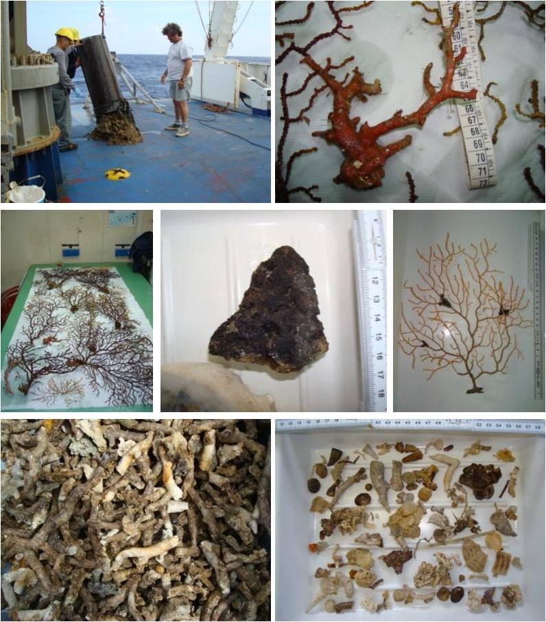
Work and specimens. A. Collection of corals with the dredge. B. Corallium
rubrum. C. Colonies of the gorgonians Paramuricea clavata and Eunicella
cavolinii. D. Rocky substrate. E. Eunicella cavolinii colony. F. Dead branches of
the scleractinian Dendrophyllia sp. G. Mixed macrofauna sample.
41
Cruise Report TYRRMOUNTS09
Activity report
Tyrrmounts 2009 cruise
r/v URANIA
May-20 - June 2 2009
U.O Dip.Te.Ris. - Università degli Studi di Genova
(Michela Castellano, Anabella Covazzi, Francesco Massa, Cristina Misic, Paolo Povero)
Corso di Laurea in Scienze Ambientali Marine - Università degli Studi di Genova
(Cecilia Baggini, Cristian Falcone, Enrico Grosso, Luca Tixi)
U.O. Dip.Te.Ris. conducted research activities during the Tyrrmount 2009 cruise in the
framework of MIUR-PRIN 2007 program “Thyrrhenian Seamounts ecosystems: an
Integrated Study –TySEc”. TySEc research activity involves different italian institutions:
Università Politecnica delle Marche, Università degli Studi di Genova, CNR ISMAR La
Spezia, INGV.
The goal of the research project is to study the hydrological features around the seamount
and their influence on the ecosystem, focusing on the relationship between water column
and sediments (pelagic-benthic coupling). The research activities were conducted on a
Tyrrhenian seamount, the Vercelli Ridge (41°05'00 N / 10°53'00 E; summit depth: 55 m).
This study will constitute a preliminary work experience in order to define an investigating
protocol useful to study many other Thyrrhenian seamount. Seamounts are major
topographic features of the ocean floor. Extending over a considerable depth range from
42
Cruise Report TYRRMOUNTS09
base to summit, and according a variety of substrate types and habitats, they constitute
unique ecosystems for biota in the open ocean.
The principal objectives of U.O. Dip.Te.Ris are:
to assess the origin, the quantity and the dynamics of the organic material within the
water column and the surface sediments at the seamount, in order to estimate the
degree of influence of the seamounts on the biogeochemical processes, focusing on
the pelagic-benthic coupling relationship. These issues are pivotal for understanding
the energy supply and transfer in ecosystems potentially controlled by topographic
elevations and they are linked to the study of the benthic communities;
to define structure and composition of the plankton community around the seamount,
focusing on the temporal and spatial variability, to investigate whether the origin is
autochthonous or allochthonous;
to define and model the trophic ecology of the seamount ecosystem.
Field activities
Samplings activities were carried out on board of the R/V URANIA (CNR) between May 20
and June 2 2009 (Tyrrmount 2009 cruise) (tab. 1)
Water samples were collected using Niskin bottles, in order to perform further chemical and
biological analyses, to determine the concentrations of the principal inorganic nutrients, the
elemental and biochemical characterization of the dissolved and particulate organic matter,
the phytoplanktonic biomass (chlorophyll-a and phaeopigments). Zooplankton samples were
collected along two transects perpendicular to the seamount using a Bongo net (200 µm).
Box-corer and grabs were use to collect the sediments and the benthos communities. In
each station of the grid sediment samples will be collected by means of box-corer to obtain a
quantitative description of the infaunal communities and a characterization of the sediments
(granulometry, elemental and biochemical content of the organic fraction, pigments content).
43
Cruise Report TYRRMOUNTS09
water
sediment
zooplankton
station
samples
samples
samples
1
41
x
3 box-corer
x
3
32
x
2 box-corer
2
30
x
-
-
4
0
x
1 grab
x
5
28
x
1 box-corer
x
6
25
x
4 box-corer
x
7
9
x
4 box-corer
x
8
11
x
-
-
9
53
x
4 box-corer
x
10
14
x
4 box-corer
x
11
16
x
4 box-corer
x
12
49
x
-
-
13
48
x
-
-
14
45
x
-
-
15
42
x
-
-
16
27
x
-
-
17
2
x
-
-
18
7
x
-
-
19
23
x
-
-
20
51
x
-
-
21
54
x
-
-
22
33
x
-
-
23
36
x
-
-
24
35
x
-
-
25
17
x
-
-
44
Cruise Report TYRRMOUNTS09
26
19
x
-
-
27
39
x
-
-
Tab. 1 sampling stations U.O Dip.Te.Ris - Università degli Studi di Genova
Laboratory activities
The analyses of seawater, sediments and benthos will be carried out at the laboratories of
Dip.Te.Ris. (Università degli Studi di Genova).
Marino Vacchi and Ugo Briozzo
In the framework of field activities of the “Tyrrmounts 09” cruise (May 2009, N/O “Urania”), fish
samplings were conducted in order to test the performances of different types of fishing gears and to
collect preliminary information on the fish assemblage of the Vercelli seamount (Central Tyrrhenian).
We adopted the three following different kinds of long-lines designed to operate along the rocky and
steep sea-beds of the Vercelli seamount: oblique long-line with 60 hooks; vertical long-line with 30
hooks; bottom long-line 160 hooks.
The fishing activities were performed between 60 m (the top of the seamount) and 450 m with long-
lines baited with frozen pilchard.
In total we made three fishing operations; The long-lines were hauled by a 24-volts electric winch. The
steepness and the high rugosity of the sea bottoms created difficulties during the hauling of the gears;
in particular the bottom long-line was severely damaged by the presence of numerous obstacles on the
sea-beds (possibly white coral banks) and several branch lines were lost.
Better results were obtained with semi-vertical (oblique) and vertical long-lines.
The catches were in general poor; we found in the long-lines only some specimens of three different
species of teleosts (Lepidopus caudatus, Muraena helena and Serranus cabrilla) and two
cartilaginous fishes (Centrophorus granulosus and Pteroplatytrygon violacea).
45
Cruise Report TYRRMOUNTS09
Preliminary Results
Weather conditions
The diagrams in figure 3 show the sea and weather conditions during the cruise.
Figure 3 Evolution of the weather conditions between 11th and 21th March 2008 (air
temperature, sea temperature, relative humidity, air pressure, wind rose, irradiance)
46
Cruise Report TYRRMOUNTS09
Hydrology
In the following some preliminary hydrological data and current measurements (LADCP data) of the
western Ionian Sea are presented.
Hydrographic sections
Figure 4 Distribution of potential temperature, salinity and oxygen along the transect NW-SE
transect W-E
47

Cruise Report TYRRMOUNTS09
Temperature , Salinity Oxygen Contour 10 m
Figure 6 Surface Contour 10 m.
48

Cruise Report TYRRMOUNTS09
Currents from LADCP
Figure 7 Distribution of the measured velocity
49
Cruise Report TYRRMOUNTS09
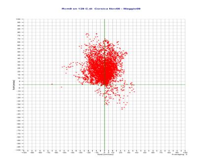
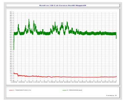
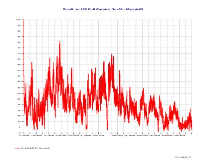
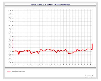
Eulerian measurements
A moorings was recovered after its it was redeployed. The data were downloaded from the internal
memories. In the following graphs we show some preliminary data elaborations.
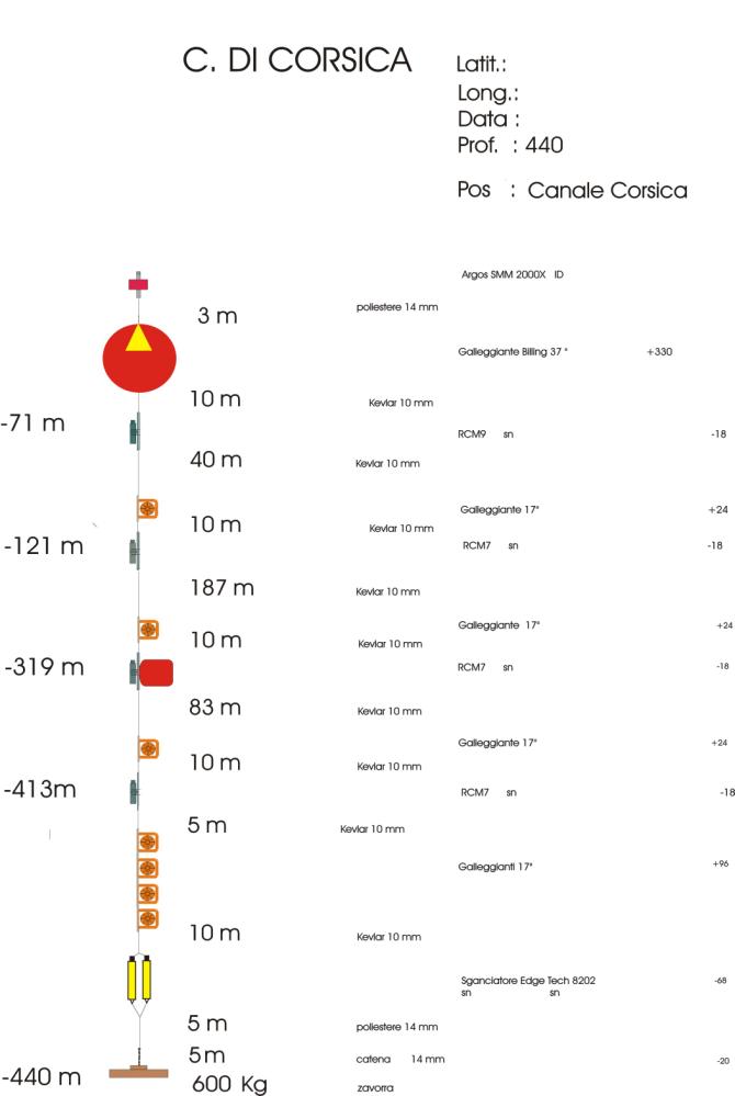
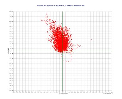
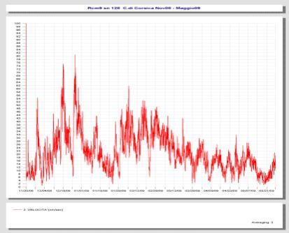
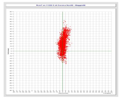
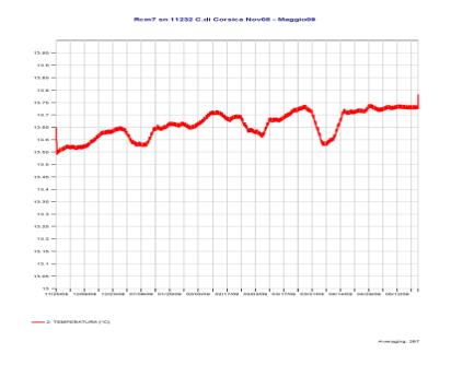
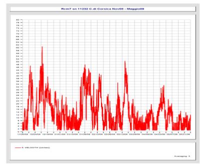
Figure 12 Scheme of the C. Channel mooring, in position 43°02.00’ N and 009°415.00’ E
50


Cruise Report TYRRMOUNTS09
51

Cruise Report TYRRMOUNTS09
Acknowledgements
The authors are deeply indebted to the Captain and the crew of the CNR R/V Urania for continuous
support during the whole measurement phase, and to the NURC NATO Undersea Research Center of
La Spezia for the possibility of periodically testing the CTD probe in the calibration bath.
52