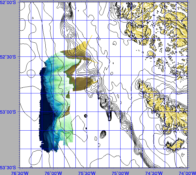
filter_bat,gridded by the nearneighbor GMT routine. The Kongskerg-Simrad's Neptune and IFREMER's Caraibes packages were used at the lab for final processing. Figures 11, 13 show some of the data acquired.
A surface of ![]() 3500 km
3500 km![]() was investigated during the cruise. Mapping on board was performed by using the PDS-2000 production DTM, converted to ASCII, filtered by ISMAR's routine
was investigated during the cruise. Mapping on board was performed by using the PDS-2000 production DTM, converted to ASCII, filtered by ISMAR's routine filter_bat,gridded by the nearneighbor GMT routine. The Kongskerg-Simrad's Neptune and IFREMER's Caraibes packages were used at the lab for final processing. Figures 11, 13 show some of the data acquired.
figure
 |
The region mapped with the multibeam system in the acretionary prism is very small relative to the total extent of the study area and is located immediately south of the Pacific entrance of the Strait of Magellan. The morphobathymetric map shows the transition from the flat seafloor of the Antarctic plate entering the subduction front and the accretionary wedge. Two major ENE/WSW trending features produce a segmentation of the outer wedge along strike.
Along these structures the outer deformation front jumps outward and shows two lateral ramps along the continuation of the sub-vertical features. The ENE-WSW trending sub-vertical faults, mark a abrupt transition between two different structural styles. North of 53S the transition between the undeformed Antarctic abyssal plain and the lower slope of the accretionary wedge occurs abruptly and produces a relatively steep slope incised by canyons that run perpendicular to the trench axis. At 53:05'S the NNW-SSE trending outer deformation front stops abruptly at a steep scarp where the seafloor rises from 4000 m in the abyssal plain to 1300 m at the scarp crest. Along this structure the outer deformation front is shifted outwards (or right laterally) by about 20 km. The structural style south of this lateral ramp changes dramatically and deformation is distributed over a wider area in the form of a set of at least four large wavelength folds that progressively shorten and uplift the Antarctic plate sediments. A meandering channel is present at the rear of the folded region. As it approaches the frontalmost folds and thrusts, its morphology appears to be strictly controlled by tectonics as described in the southern Barbados prism [Huyghe et al.(2004)].
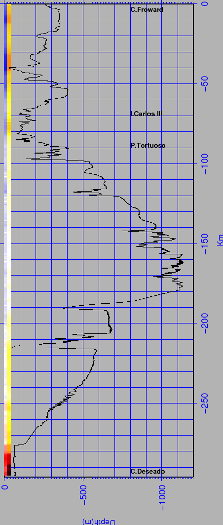
The bathymetric data in the Strait show a very rough morphology. Figure 12 presents the rectified profile along the channel, from Cape Froward to the Pacific Ocean. figure
 |
figure