 |
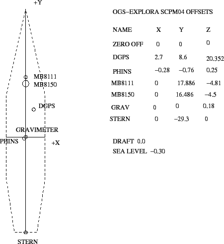
The vessel was set-up for multibeam data acquisition and navigation with PDS-2000 software by RESON, that collected data from Ashtech's DGPS and IXEA's PHINS navigation sources, and swath bathymetry from RESON's 8111 and 8150 Multibeam systems, and providing also the acquisition and data display of additional data sources, among them a Bodenseewerk KSS1 Gravimeter and a OGS ASW meteorologic station.
The hull-mounted 16 transducer BENTHOS Chirp system was used, with data flow and performance controlled by the Communication Technology's SWANPRO software. The SBP-CHIRP workstation received positions trough a sentence by the PDS-2000 and positions were therefore recorded on the SEG-Y trace headers as lat/long of the DGPS antenna.
The gravimeter was interfaced to the RPH attitude and navigation data by NMEA sentences provided by the PDS-2000.
The instrumental offsets (PDS-2000) are presented in Fig. 10 and in Tab. 3
figure