 |
The Bay of Kotor, considered to be the southernmost fjord of Europe, is composed by three embayments, with average depths ranging from 20 to 40m, connected by shallower and narrow straits (e.g. the Verige S., 350m wide), and dominated by mountains of the Dynarides Range as high as 2000m (Mt.Orjen, that dominates to the NW the Bay of Risan, 1894m), with well expressed karst entirety and aquifers discharging on the coast and also below the sea level.
For example, on the northern bay, with the cities of Kotor to the SE and Risan to the NW, several authors reported springs and siphons well studied and explored by divers even at depth of -170m, among them the Sopot just SE of Risan, which also springs at sea at a depth of 25-30m [Milanovic(2007)], [Eusebio et al.(2005)], [Bordin(2007)]. Another spring was reported east of the Gospa od Skrpjela Islet, on the northern coast of the Kotor bay, between Perast and C.Drazin by Montenegrinian colleagues on board.
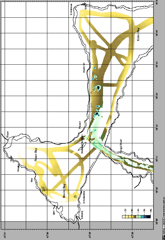
We therefore payed a special attention on mapping by multibeam the nearshore area, in spite of the little time available, resulting with some intersting findings on the Kotor and Risan bays (Fig. 14) which may resemble submarine karst springs morphologies, e.g. circular, sub-circular or elliptical depressions or pits, with maximum measured depths of 35m from a rather flat seafloor of 30m depth.Figure 15 presents a CHIRP image of these morphologies, evidencing also a possible stage of formation by deeper aquifer fluxes and sediment dissolution. The deepest and largest of these pits was investigated by CTD and sampled by grab, reporting anoxic, seawater conditions on bottom.
The investigations on the western Bays of Risan and Morinj, altough not able to map in detail the submarine spring of Sopot, close to the village of Vitoglav, were able to evidence morphological features similar to the ones found on Kotor Bay. These features, lying on seabottoms 25-30m deep, may also have been formed by karstic resurgences, especially the ones found NE of the Island close to the city of Perast and on the S, in front of the village of D.Kostanjica, east of D.Morin. These last locality is interested by nearshore resurgences, which experience salting on low-discharge conditions.
The Verige Strait, connecting the Central Bay of Tivat to the Bay of Kotor, shows very steep flanks that continue into the embayment, being stopped by a steep, narrow ridge, parallel to the S coastline, which elevates above surface with the man-made Island of Gospa od Skrpjela
The Bay of Tivat was mapped mostly on the northern (city of Bijela) and Southern flanks, whereas the Herceg-Novi area was mostly investigated on its borders and on the main entrance from C.Ostra to the Mamula I., including the Ploca shoal.
Chirp data showed extremely interesting subbottom geometries, among them compressional structures on the Verige strait (16), 20-30m thick sedimentary sequences in the Bays of Tivat (Fig.17) and Herzeg-Novi (Fig.18).
The shelf and shelf break area south of the Bay of Kotor was mapped, from the limit of croatian waters to the E. Figure 19 shows and example of the CHIRP records.
figure
figure
figure
figurefigure
figure