next up previous contents
Next: LAND Up: WIDE ANGLE REFRACTION SEISMIC Previous: WIDE ANGLE REFRACTION SEISMIC   Contents

MARINE

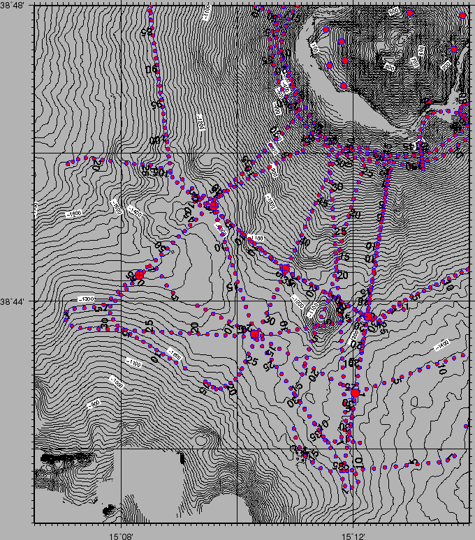
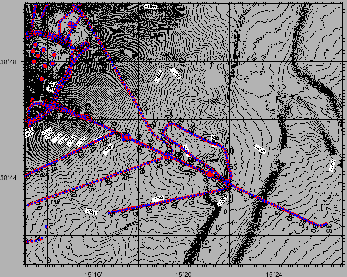
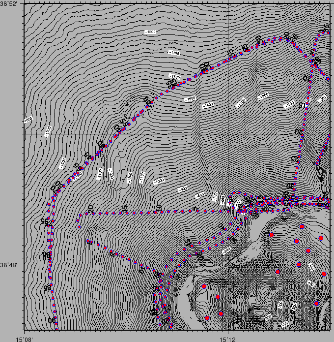
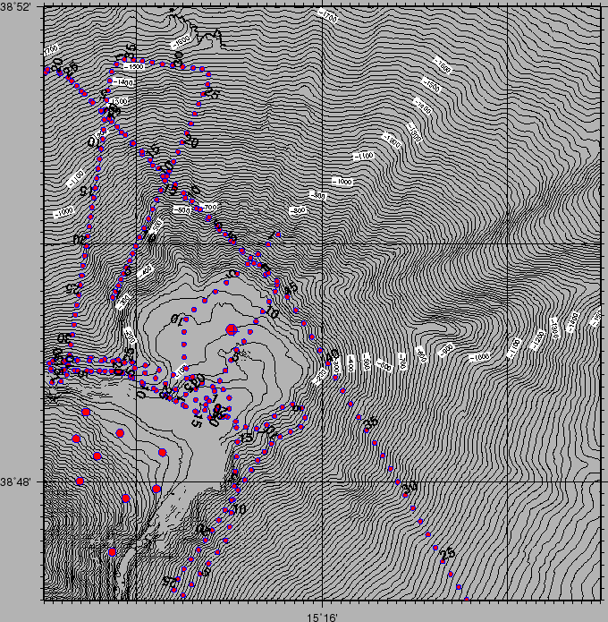
Figures 18,19,20,21 show the pattern of the seismic stations shooted during the cruise (Table 19). The shooting mode was based on time (every 9-120 s) rather than on distance, since the compressor's air delivery could have been more easily controlled. Direct communications with INGV people monitoring the on-land network was able to provide information for fine tuning of the shooting lines.

OBS were recovered 2006-12-02. Appendix 7.4 reports the coordinates of release and overboard recovery of the OBS stations (Tables 16, 17) and the clock drifts (Table 18).

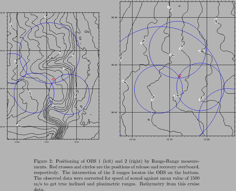
Figures 16, and 17 show the locations of OBS 1,2 and 3, derived from trilateration of range measurements by pinger.

\begin{figure}
% latex2html id marker 993
\centerline{
\epsfig{file=IMG/STR06_O...
...inclined and planimetric ranges. Bathymetry from this cruise data.}
\end{figure}

\begin{figure}
% latex2html id marker 999
\centerline{
\epsfig{file=IMG/STR06_O...
...e measurements. Caption is the same as Fig.\ref{OBS_TRILAT_POS1}. }
\end{figure}

figure

Figure 18: Shots map in the SW sector of Stromboli. Bathymetry from this cruise data and [Marani, Gamberi and Bonatti(2004)],[Bortoluzzi et al.(1999)] deeper than 2200 m. Topography from SRTM.
\begin{figure}\centerline{
\epsfig{file=IMG/STR06_NAV_SHOTS_SW.eps,width=15cm}}\quad
\end{figure}
figure
Figure 19: Shots map in the SE sector of Stromboli. Bathymetry from this cruise data and [Marani, Gamberi and Bonatti(2004)],[Bortoluzzi et al.(1999)] deeper than 2200 m. Topography from SRTM.
\begin{figure}\centerline{
\epsfig{file=IMG/STR06_NAV_SHOTS_SE.eps,width=15cm}}\quad
\end{figure}
figure
Figure 20: Shots map in the NW sector of Stromboli. Bathymetry from this cruise data and [Marani, Gamberi and Bonatti(2004)],[Bortoluzzi et al.(1999)] deeper than 2200 m. Topography from SRTM.
\begin{figure}\centerline{
\epsfig{file=IMG/STR06_NAV_SHOTS_NW.eps,width=15cm}}\quad
\end{figure}
figure
Figure 21: Shots map in the NE sector of Stromboli. Bathymetry from this cruise data and [Marani, Gamberi and Bonatti(2004)],[Bortoluzzi et al.(1999)] deeper than 2200 m. Topography from SRTM.
\begin{figure}\centerline{
\epsfig{file=IMG/STR06_NAV_SHOTS_NE.eps,width=15cm}}\quad
\end{figure}

figure

Figure 22: Trigger table from on-board seismograph.
\begin{figure}\centerline{
\epsfig{file=IMG/trigger.newtable.ps,width=15cm}}\quad
\end{figure}

The analysis of the recording of shots made by a seismometer on board (Fig. 22) and its comparison with shots table was able to evidence some problems in timing and signature quality for days 29 and 30 november. The data downloaded from each OBS after their recovery on board were checked for clock drifts and assembled in chunks of 40 s long records in the SEG-Y format, starting at the whole second of every Seismic Shot. Other SEG-Y files accomodated the entire OBS data set. Appendix 7.4 gives furter details and description of the conversion procedure to the SAC format ([SAC (2006)],[Goldstein et al. (2003)]). All OBS well recorded seismic data except for OBS06, due to hardware failure.

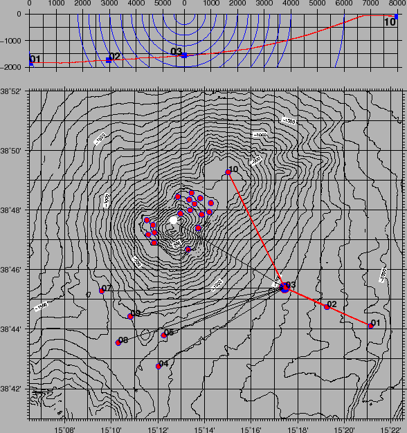
In Figure 24 the vertical component seismograms recorded by 9 OBS after shot 5/L39 (2006-12-02T01:46:38.090, ESE of Stromboli, fig.19 and 23) are presented. Planar distances from the source to the nearest (03) and the farthest (07) OBS range between few m (nearly vertical) and 11 km, while distance from source to the Stromboli craters area is about 8 km. See in table 14 the distances from the recording stations. Recording conditions (signal-to-noise ratio "S/N") were almost good enough to allow all OBS to detect the signals, while data quality from the different OBS is variable, depending on the distance from seismic source. OBS data close to source are generally of good quality (Fig. 24), left), and in several cases clear second and third (exceptionally up to fourth) arrivals can be identified (Fig. 25 , right). Most of the records display an impulsive first arrival recorded only at close distances from the shot site. On distant shots data quality is poorer, however picking procedure of incoming waves is still possible on the emergent phases by applying a filter. From the pattern of recorded seismograms, we may deduce that the data quality of each OBS is probably depending on the local geology and considerably affected by the presence of the volcanic structures. These latter are characterised by remarkable velocity variations in the lateral direction, and are likely to influence the spreading of seismic phases.


Table 14: Shot 5/39. Picking time of arrivals and goodness codes, distances (inclined,planar), azimuth from Recording Stations, difference between picked and espected time of arrivals, calculated by integrating travelled distances with sound velocity profile of fig.30. Picking codes: 1234 1=start time of phase (Impulsive,Emerging); 2=Phase (P,S); 4=goodness of picking (0 +/- 0.05s).
SHOT Lon Lat Depth Date Time      
5-39 15.290816 38.756682 -6.0 2006-12-02 01:46:38.090      
OBS PTime PCode IDist PDist PAzim Depth ETime TDiff
OBS03 01:46:39.086 IP_0 1557 62 79 -1561 01:46:39.113 0.027
OBS02 01:46:40.388 IP_0 3369 2888 114 -1739 01:46:40.301 -0.087
OBS01 01:46:42.258 IP_0 6141 5863 113 -1834 01:46:42.123 -0.135
OBS10 01:46:41.841 EP_2 7987 7986 333 -98 01:46:43.350 1.509
OBS05 01:46:43.361 IP_0 8187 8089 248 -1265 01:46:43.481 0.120
OBS04 01:46:44.118 IPD0 9341 9247 238 -1333 01:46:44.239 0.121
OBS09 01:46:44.753 _P_1 9834 9765 259 -1176 01:46:44.567 -0.186
OBS08 01:46:45.531 IP_0 10985 10911 251 -1282 01:46:45.324 -0.207
OBS07 01:46:43.687 _P_2 11446 11374 268 -1293 01:46:45.627 1.940


figure

Figure 23: Shot 5/39, OBS and Land Stations (also shown the 'Craters' point, NW of Stromboli top (925m), height 750m). On top the X-Z plot of OBS 01,02,03 and 10 and of the bathymetry; horizontal and vertical scales are the same.
\begin{figure}\centerline{
\epsfig{file=IMG/STR06_SHOT_5-39.eps,width=13cm}}
\end{figure}

figure

Figure 24: Example of one shot gather from OBS data recordings (vertical component).
\begin{figure}\centerline{
\epsfig{file=IMG/061202_0146.eps,width=17.5cm}}
\end{figure}

figure

Figure 25: Vertical component seismograms from OBS01 (right) and OBS03(left).
\begin{figure}\centerline{
\epsfig{file=IMG/061202_0146_OBS01_OBS03.eps,width=17.5cm}}
\end{figure}


next up previous contents
Next: LAND Up: WIDE ANGLE REFRACTION SEISMIC Previous: WIDE ANGLE REFRACTION SEISMIC   Contents
2007-06-18