The original M3A configuration was designed to use high quality and world-wide referenced sensors. For the E1-M3A system in the Cretan Sea, already developed during the past project MFSPP [Nittis et al.(2003)], sensors from Seabird Inc. were mainly selected for measuring chemical-physical parameters of the sea water.
figure
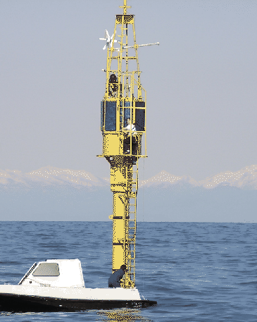
The W1-M3A system (Fig.11) can be briefly described by the following characteristics:
By summarising, W1-M3A is able to collect CT (Condictivity/Temperature) measures at six depths from the surface down to about 50 m, CT + turbidity + fluorescence + dissolved oxygen + chlorophyll at about -40 m, sea waves statistics, water current at two depths above the damping disk with mechanical sensors and current below the buoy with an ADCP. For what concern the meteorological parameters, W1- M3A measures atmospheric pressure (with a mechanical and a piezoelectric sensors), wind speed and direction, air temperature and relative humidity (with a sensor in a standard shield and another one in a ventilated shield), precipitation, global solar radiation. Other measured parameters are: buoy geographical position, inclination (roll and pitch angles) and heading, DC current by the eight solar panels, and on- board battery charge.
Table 4 presents the mooring coordinates by analyzing a several months time series of the on-board GPS data:
Since the buoy has a slack mooring, it freely moves within a circle with a diameter of about 3.2 Km (precisely, 3.259 Km along East and 3.240 Km along North).
The buoy occupies positions resulting from the composition of two main forces (the sea wave and the wind) with the constraint of the mooring line. A more refined analysis can reveal that northern positions occur with light winds whereas southern positions are associated with strong northern winds: however, since the prevailing and almost constant current stream flows towards North, in case of northerly winds the resultant positions are in the south-western sector rather than in the southern sector itself.
Further information of Instrumental payloads and buoy activity can be found in the ODAS buoy WWW homepage.