next up previous contents
Next: SCIENTIFIC AND TECHNICAL PARTIES Up: MARM09_REP Previous: INTRODUCTION AND BACKGROUNDS   Contents


CRUISE SUMMARY

SHIP: R/V Urania  Flag: Italy [IT] Call Sign: IQSU IMO: 9013220, MMSI: 247498000 START: 2009-09-22 PORT: Brindisi
END: 2009-10-12 PORT: Messina
SEA/OCEAN: Sea of Marmara, Mediterranean Sea
LIMITS: NORTH 40:00.0 SOUTH: 41:15.0 WEST: 25:30.0 EAST: 30:00
OBJECTIVE: Active Faults and historical earthquakes in the Marmara Sea
COORDINATING BODIES: ISMAR-Bologna BOLOGNA (ITALY)
CHIEF OF EXPEDITION: Luca Gasperini (ISMAR-CNR)
CONTACT: Luca.Gasperini@ismar.cnr.it
DISCIPLINES: MARINE GEOLOGY, MARINE GEOPHYSICS, PHYSICAL OCEANOGRAPHY, CHEMICAL OCEANOGRAPHY, BOTTOM OBSERVATORIES
WORK DONE: SN4, 10 OBS, 5 PIEZOMETERS DEPLOYMENT, MEDUSA INVESTIGATIONS
850 KM$^2$ MULTIBEAM, 1650 KM SBP
11 GRAVITY CORES , 4 SW CORES, 15 CTD CASTS, 18 XBT,

LOCALIZATION:

figure

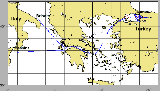
Figure 3: General ship track during Cruise MARM09, including transits from Brindisi and to Messina. Circles with small circle are OBS, rhombs with circle are piezometers, hollows are CTD stations.
\begin{figure}\centerline{\epsfig{
file=IMG/MARM09_NAV_GEN.eps,width=\linewidth}}
\end{figure}
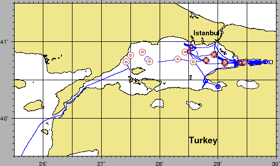
Figure 4: Ship track during Cruise MARM09 in the Marmara Sea. Circles with small circle are OBS, rhombs with circle are piezometers, hollows are CTD stations.
\begin{figure}\centerline{\epsfig{
file=IMG/MARM09_NAV_CRUISE.eps,width=\linewidth}}
\end{figure}
figure
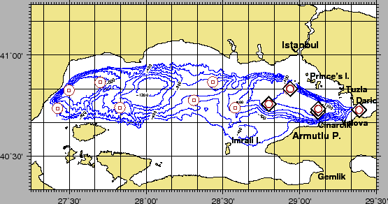
Figure 5: Deployment sites of piezometers and OBS..
\begin{figure}\centerline{\epsfig{
file=IMG/MARM09_PIEZO_OBS.eps,width=\linewidth}}
\end{figure}

figure

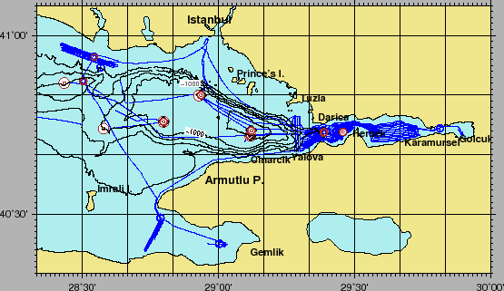
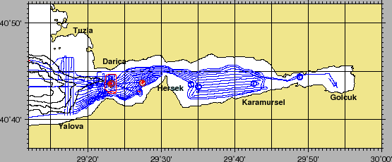
Figure 6: Navigation in Çinarcikand Izmitregions.Circles with small circle are OBS, rhombs with circle are piezometers, hollows are CTD stations.
\begin{figure}\centerline{\epsfig{
file=IMG/MARM09_NAV_CINARCIK.eps,width=\linewidth}}
\end{figure}
Figure 7: Navigation in Izmitregions.Circles with small circle are OBS, rhombs with circle are piezometers, hollows are CTD stations.
\begin{figure}\centerline{\epsfig{
file=IMG/MARM09_NAV_IZMIT.eps,width=\linewidth}}
\end{figure}


Table 2: Cruise MARM09, operations at sea. Latitude, Longitude true position, Time UTC
LAT LON(TRUE) UTM35(TRUE) LAT LON HDG(SHIP) TIME(UTC) OPERATION
2725.3936 4044.2150 535735 4509639 2725.3912 4044.2229 16.7 2009-09-27T03:06:04 OBS01-LV03-
2729.9079 4049.5494 542032 4519542 2729.9070 4049.5575 24.7 2009-09-27T04:45:42 OBS02-LV11-
2742.0275 4051.8859 559030 4523981 2742.0366 4051.8902 87.7 2009-09-27T06:16:09 OBS03-LV02-
2749.7209 4044.4076 569967 4510240 2749.7307 4044.4044 142.7 2009-09-27T07:19:41 OBS04-LV07-
2818.5332 4046.5612 610453 4514718 2818.5389 4046.5680 62.4 2009-09-27T09:48:00 OBS05-LV12-
2834.6671 4044.3661 633218 4511030 2834.6762 4044.3619 151.4 2009-09-27T11:18:06 OBS06-LV09-
2847.8815 4045.5070 651771 4513498 2847.8816 4045.5120 45.3 2009-09-27T13:18:01 MPZ-01-
2847.8665 4045.5046 651750 4513493 2847.8869 4045.5140 60.5 2009-09-27T15:36:01 PZ-A-
2847.8779 4045.5176 651766 4513518 2847.8880 4045.5150 137.7 2009-09-27T17:19:18 OBS07-LV05-
2825.9607 4052.0406 620734 4525019 2825.9501 4052.0416 307.0 2009-09-27T20:03:59 OBS08-LV08-
2907.0277 4043.1575 678813 4509752 2907.0515 4043.1583 89.4 2009-09-28T08:39:32 PZ-B-
2906.9286 4043.1818 678673 4509794 2906.9336 4043.1851 93.6 2009-09-28T11:09:21 MPZ-02-
2907.0253 4043.1647 678809 4509765 2907.0352 4043.1676 97.9 2009-09-28T11:54:17 OBS09-LV10-
2907.2033 4044.0456 679021 4511401 2907.2270 4044.0433 99.1 2009-09-28T13:05:47 PZ-C-
2907.2564 4044.0267 679096 4511368 2907.2597 4044.0311 74.9 2009-09-28T14:30:23 MPZ-03-
2855.6879 4049.9109 662575 4521880 2855.6950 4049.9169 71.4 2009-09-28T17:33:18 OBS10-LV01-
2923.1766 4043.6859 701521 4511313 2923.1701 4043.6867 324.5 2009-09-29T06:19:45 MPZ-04-
2923.1742 4043.6853 701517 4511312 2923.1539 4043.6948 303.4 2009-09-29T07:48:34 PZ-D-
2856.2232 4050.0033 663323 4522067 2856.2044 4050.0145 309.6 2009-09-29T12:48:18 PZ-E-
2856.1343 4049.9861 663199 4522033 2856.1283 4049.9882 339.9 2009-09-29T14:04:03 MPZ-05-
2923.0715 4043.7790 701368 4511481 2923.0483 4043.7749 258.4 2009-10-03T06:22:15 MSN-BC01-
2923.0737 4043.7880 701371 4511498 2923.0974 4043.7860 98.3 2009-10-03T07:02:42 MSN-BC02-
2923.2642 4043.7372 701641 4511411 2923.2610 4043.7416 15.7 2009-10-03T08:57:43 MSN-C01-
2923.2519 4043.7479 701624 4511431 2923.2453 4043.7470 305.0 2009-10-03T10:13:11 MSN-C02-
2923.2456 4043.7445 701615 4511424 2923.2441 4043.7396 237.6 2009-10-03T11:28:35 MSN-C03-
2923.2393 4043.7452 701606 4511425 2923.2211 4043.7569 312.0 2009-10-04T15:56:16 SN4-
2923.2410 4043.7433 701609 4511422 2923.2254 4043.7571 321.1 2009-10-04T16:14:17 SN4-RELEASE
2923.2990 4043.7636 701689 4511462 2923.3224 4043.7601 102.8 2009-10-04T18.46.00 SN4-RESPONSE
2923.2356 4043.7429 701601 4511421 2923.2366 4043.7380 216.2 2009-10-05T06:56:21 SN4-FM-MEDUSA
2923.3125 4043.7381 701709 4511415 2923.3180 4043.7409 101.2 2009-10-06T08:01:09 MSN-SW01-
2923.3166 4043.7361 701715 4511411 2923.3218 4043.7392 97.1 2009-10-06T08:44:05 MSN-SW02-
2927.4719 4043.7841 707562 4511662 2927.4744 4043.7794 202.6 2009-10-06T10:08:18 MSP-C01-
2927.4790 4043.7832 707572 4511660 2927.4729 4043.7812 291.6 2009-10-06T11:47:57 MSP-C02-
2830.2163 4052.2810 626703 4525564 2830.2144 4052.2858 28.5 2009-10-07T12:22:24 MEI-C01-
2830.2213 4052.2798 626710 4525562 2830.2181 4052.2842 16.3 2009-10-07T12:55:30 MEI-SW01-
2830.2238 4052.2782 626714 4525559 2830.2228 4052.2831 36.1 2009-10-07T13:39:20 MEI-C02-
2832.5955 4056.3491 629912 4533149 2832.5939 4056.3540 31.2 2009-10-07T14:53:04 MEI-SW02-


Table 3: CTD and XBT positions, Time is UTC
LON LAT DATE_TIME STATION
1854.29 3956.57 2009-09-23T15:55:05 XBT-01069417
1904.22 3948.19 2009-09-23T16:59:43 XBT-01069417
1916.78 3937.81 2009-09-23T18:17:20 XBT-01069406
1917.24 3936.78 2009-09-23T18:25:06 XBT-00000000
1919.46 3934.79 2009-09-23T18:39:58 XBT-00000000
1920.19 3934.14 2009-09-23T18:44:48 XBT-00000000
1927.58 3927.69 2009-09-23T19:33:34 XBT-01069421
1937.30 3919.74 2009-09-23T20:39:32 XBT-01069422
1949.14 3908.75 2009-09-23T22:00:12 XBT-01069416
1959.53 3900.15 2009-09-23T23:10:02 XBT-01069418
2012.90 3848.75 2009-09-24T00:39:47 XBT-01069425
2020.14 3841.88 2009-09-24T01:32:31 XBT-01069423
2025.19 3837.60 2009-09-24T02:06:40 XBT-01069410
2227.36 3810.70 2009-09-24T12:26:14 XBT-01069414
2457.39 3825.41 2009-09-25T03:46:47 XBT-00000000
2532.48 3923.23 2009-09-25T09:41:42 XBT-01069419
2735.56 4052.43 2009-09-27T05:35:57 XBT-01069758
2747.57 4046.37 2009-09-27T07:00:56 XBT-01069411
2533.64 3923.68 2009-10-09T13:21:42 XBT-01069407
2452.40 3816.52 2009-10-09T19:52:09 XBT-01069403
2233.85 3808.36 2009-10-10T08:46:18 XBT-01069754
2023.43 3759.13 2009-10-10T18:33:53 XBT-01069908
2004.11 3758.50 2009-10-10T19:53:25 XBT-01069741
1943.23 3758.34 2009-10-10T21:18:34 XBT-01069909
1826.13 3757.22 2009-10-11T02:37:19 XBT-01069916
1748.20 3756.54 2009-10-11T05:19:30 XBT-01069913
1728.82 3755.91 2009-10-11T06:44:56 XBT-01069745
1703.73 3754.99 2009-10-11T08:29:26 XBT-01069743
1639.46 3754.35 2009-10-11T10:16:03 XBT-01069749
1611.63 3753.49 2009-10-11T12:15:09 XBT-01069749
1537.16 3805.79 2009-10-11T15:19:23 XBT-01069742
2907.06 4043.16 2009-09-28T05:44:14 CTD_04
2855.70 4049.90 2009-09-28T17:07:54 CTD_05
2921.18 4044.07 2009-09-29T05:11:25 CTD_06
2834.02 4054.67 2009-09-29T17:53:33 CTD_07
2923.10 4043.95 2009-09-01T05:21:57 CTD_08
2935.08 4043.38 2009-09-01T19:02:30 CTD_09
2942.63 4043.72 2009-09-01T20:28:13 CTD_10
2948.87 4044.43 2009-09-02T06:04:08 CTD_11
2923.05 4043.77 2009-09-03T05:41:37 CTD_12
2923.23 4043.74 2009-09-04T10:48:40 CTD_13
2920.34 4043.55 2009-09-04T19:50:30 CTD_14
2927.48 4043.78 2009-09-05T22:21:22 CTD_15
2934.07 4043.64 2009-09-06T13:17:35 CTD_16
2847.21 4029.38 2009-09-06T22:37:07 CTD_17
2900.21 4024.98 2009-09-07T05:44:13 CTD_18
2832.57 4056.38 2009-09-07T15:12:41 CTD_19


next up previous contents
Next: SCIENTIFIC AND TECHNICAL PARTIES Up: MARM09_REP Previous: INTRODUCTION AND BACKGROUNDS   Contents
2010-04-06