


Next: CTD AND SOUND VELOCITY
Up: MATERIALS AND METHODS
Previous: MATERIALS AND METHODS
Contents
The vessel was set-up for multibeam data acquisition and navigation with RESON
PDS-2000
and
COMM-TECH
NAVPRO softwares.
Two workstations were used forthe acquisition of
- (PDS-2000) multibeam data, interfacing by a multiserial and Ethernet link a
RESON 8160 P1 processor, an TSS MAHRS MRU and FOG compass,
DGPS receiver, by a MOXA Multi/serial I/O, TC/P and UDP network
sockets;
- (NAVPRO) Microtecnica gyrocompass, Atlas Krupp's DESO echosounders, coring cable
tension and the DGPS receiver, by a Digiboard Multi/serial I/O card.
The latter workstation also collected the navigational data every 5 minutes.
The MBES was the 50kHz, 126 0.5°, 150°aperture RESON 8160
(5000 m range).
The sonar head is positioned on the ship's keel
using a V-shaped steel frame. A sound velocity probe at the Sonar Head is interfaced
directly to the MBES processor, thus providing the necessary real-time data for the
beam-forming.
The datum WGS84 and the UTM, zone 35, were chosen for
navigation and display purposes. Timing was set to UTC for data acquisition.
The PDS-2000 production DTM was set to grid sizes ranging from 1 to 15-20m.
The SBP-CHIRP workstation
received positions trough an NMEA sentence by the DGPS receiver.
The positions were therefore recorded on the XTF trace headers as lat/long of
the DGPS antenna.
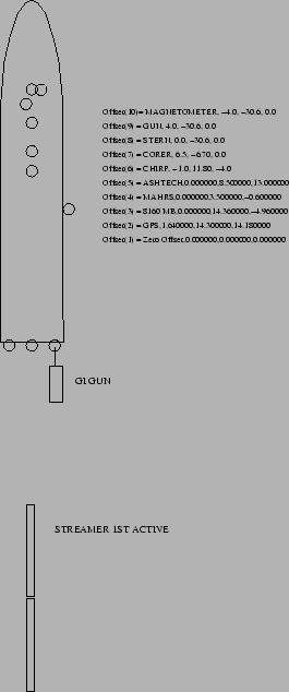
The instrumental offsets (PDS-2000) are presented in Fig. 14 and
in Tab. 3
Table 3:
Instrumental Offsets on Ship Urania (PDS2000).
The GPS antenna (primary positioning system) is located on point
DGPS.
| POSITION |
ACROSS |
ALONG |
HEIGHT |
| REFERENCE |
0.00 |
0.00 |
0.00 |
| DGPS |
1.64 |
14.30 |
14.18 |
| MBEAM |
0.00 |
14.36 |
-4.96 |
| MAHRS |
0.00 |
0.0 |
-3.40 |
| CHIRP |
-1.0 |
11.80 |
-4.00 |
| CORER |
6.5 |
-6.70 |
0.0 |
| STERN |
0.00 |
-30.60 |
0.00 |
| STERN-LEFT |
-4.00 |
-30.60 |
0.0 |
| STERN-RIGHT |
4.00 |
-30.60 |
0.0 |
| GI-GUN ARRAY |
4.0 |
-48.0 |
0.0 |
| FIRST ACTIVE 48CH |
0.0 |
-168.0 |
0.0 |
|
figure
Figure 14:
Cruise MARM05. Instrumental Offsets (PDS-2000) on R/V Urania
 |
Next: CTD AND SOUND VELOCITY
Up: MATERIALS AND METHODS
Previous: MATERIALS AND METHODS
Contents
2005-12-08